Back Propinsi Apayao ACE آبايو Arabic آپایو AZB Apayao BCL Apayao CBK-ZAM Apayao CEB Apayao German Apayao Spanish آپایو Persian Apayao Finnish
Apayao | |
|---|---|
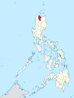
 Location in the Philippines | |
| Coordinates: 17°45′N 121°15′E / 17.75°N 121.25°E | |
| Country | Philippines |
| Region | Cordillera Administrative Region |
| Founded | May 8, 1995 |
| Capital | Kabugao* |
| Administrative center | Luna |
| Largest municipality | Conner |
| Government | |
| • Governor | Elias C. Bulut Jr. (NPC) |
| • Vice Governor | Remy N. Albano (KBL) |
| • Legislature | Apayao Provincial Board |
| Area | |
• Total | 4,413.35 km2 (1,704.00 sq mi) |
| • Rank | 27th out of 81 |
| Highest elevation | 1,921 m (6,302 ft) |
| Population (2020 census)[3] | |
• Total | 124,366 |
• Estimate (2020) | 123,898[2] |
| • Rank | 78th out of 81 |
| • Density | 28/km2 (73/sq mi) |
| • Rank | 81st out of 81 |
| Divisions | |
| • Independent cities | 0 |
| • Component cities | 0 |
| • Municipalities | |
| • Barangays | 133 |
| • Districts | Legislative district of Apayao |
| Time zone | UTC+8 (PHT) |
| ZIP code | 3807–3814 |
| IDD : area code | +63 (0)74 |
| ISO 3166 code | PH-APA |
| Spoken languages | |
| Website | www |
| * Kabugao is the officially recognized capital and seat of government, although the province carries out many of its operations in a new government center established in Luna. | |
Apayao, officially the Province of Apayao (Ilocano: Probinsia ti Apayao; Itawit: Provinsiya ya Apayao; Isnag: Provinsia nga Apayao; Tagalog: Lalawigan ng Apayao), is a landlocked province in the Philippines in the Cordillera Administrative Region in Luzon. Kabugao serves as its capital. The provincial capitol and its associated offices are located at the New Government Center in Luna.
The province borders Cagayan to the north and east, Abra and Ilocos Norte to the west, and Kalinga to the south. Prior to 1995, Kalinga and Apayao comprised a single province named Kalinga-Apayao, which was partitioned to better service the needs of individual ethnic groups.
With a population of 124,366 (as of the 2020 census)[3] covering an area of 4,413.35 square kilometres (1,704.00 sq mi),[1] Apayao is the least densely-populated province in the Philippines, the least developed province in Luzon and one of the poorest.
- ^ a b "List of Provinces". PSGC Interactive. Makati, Philippines: National Statistical Coordination Board. Archived from the original on 19 April 2016. Retrieved 5 March 2020.
- ^ "POPULATION PROJECTIONS BY REGION, PROVINCE, CITIES AND MUNICIPALITIES, 2020-2025". www.doh.gov.ph. Department of Health. August 27, 2020. Archived from the original on May 14, 2021. Retrieved October 16, 2020.
- ^ a b Census of Population (2020). Table B - Population and Annual Growth Rates by Province, City, and Municipality - By Region. Philippine Statistics Authority. Retrieved 8 July 2021.


