Back Beverwijk Afrikaans Beverwijk AN بيفيرفايك Arabic Beverwijk BAN Beverwijk Breton Beverwijk Catalan Gemeente Beverwijk CEB Beverwijk German Beverwijk Esperanto Beverwijk Spanish
Beverwijk | |
|---|---|
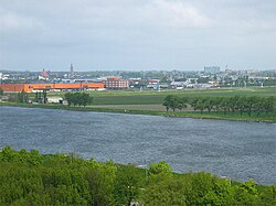
 Beverwijk as seen from the North Sea Canal | |
|
| |
 Location in North Holland | |
| Coordinates: 52°29′N 4°39′E / 52.483°N 4.650°E | |
| Country | Netherlands |
| Province | North Holland |
| Region | Amsterdam metropolitan area |
| Government | |
| • Body | Municipal council |
| • Mayor | Martijn Smit (PvdA) |
| Area | |
• Total | 20.09 km2 (7.76 sq mi) |
| • Land | 18.40 km2 (7.10 sq mi) |
| • Water | 1.69 km2 (0.65 sq mi) |
| Elevation | 2 m (7 ft) |
| Population (January 2021)[4] | |
• Total | 41,863 |
| • Density | 2,275/km2 (5,890/sq mi) |
| Demonym | Beverwijker |
| Time zone | UTC+1 (CET) |
| • Summer (DST) | UTC+2 (CEST) |
| Postcode | 1940–1949 |
| Area code | 251 |
| Website | www |

Beverwijk (Dutch pronunciation: [ˌbeːvərˈʋɛik] ) is a municipality and a city in the Netherlands, in the province of North Holland. The town is located about 20 kilometres (12 mi) northwest of Amsterdam in the Randstad metropolitan area, north of the North Sea Canal very close to the North Sea coast. A railway tunnel and two motorway tunnels cross the canal between Beverwijk and the nearby city of Haarlem on the south side of the canal.
Around 1640, a town called Beverwyck was founded in the Dutch colony of New Netherland. That town's modern name is Albany, New York.
- ^ "College van B en W" [Board of mayor and aldermen] (in Dutch). Gemeente Beverwijk. Archived from the original on 15 April 2012. Retrieved 24 February 2014.
- ^ "Kerncijfers wijken en buurten 2020" [Key figures for neighbourhoods 2020]. StatLine (in Dutch). CBS. 24 July 2020. Retrieved 19 September 2020.
- ^ "Postcodetool for 1948LC". Actueel Hoogtebestand Nederland (in Dutch). Het Waterschapshuis. Retrieved 24 February 2014.
- ^ "Bevolkingsontwikkeling; regio per maand" [Population growth; regions per month]. CBS Statline (in Dutch). CBS. 1 January 2021. Retrieved 2 January 2022.

