Back وادي كاغيان Arabic Rehiyon Cagayan BCL Saonenn Cagayan Breton Vall de Cagayan Catalan Valle de Cagayán CBK-ZAM Lupot sa Cagayan CEB Cagayan Valley German Kagajana Valo Esperanto Valle del Cagayán Spanish Cagayan Harana Basque
Cagayan Valley
Tanap ti Cagayan | |
|---|---|
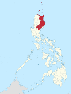
 Location in the Philippines | |
| Country | |
| Island group | Luzon |
| Regional center and largest city | Tuguegarao |
| Area | |
| • Total | 28,228.83 km2 (10,899.21 sq mi) |
| Highest elevation | 2,928 m (9,606 ft) |
| Population (2020 census)[2] | |
| • Total | 3,685,744 |
| • Estimate (2020) | 3,657,741[1] |
| • Density | 130/km2 (340/sq mi) |
| Time zone | UTC+8 (PST) |
| ISO 3166 code | PH-02 |
| Provinces | |
| Independent cities | 1 |
| Component cities | |
| Municipalities | 89 |
| Barangays | 2,311 |
| Cong. districts | 12[3] |
| Languages | |
| GDP (2023) | ₱510.83 billion $9.18 billion[4] |
| Growth rate | |
| HDI | |
| HDI rank | 7th in the Philippines (2019) |
Cagayan Valley (Ilocano: Tanap ti Cagayan; Filipino: Lambak ng Cagayan), designated as Region II, is an administrative region in the Philippines. Located in the northeastern section of Luzon,[5] it is composed of five Philippine provinces: Batanes, Cagayan, Isabela, Nueva Vizcaya, and Quirino. The region hosts four chartered cities: Cauayan, Ilagan, Santiago, and Tuguegarao (the regional center and largest city).[6]
Most of its land area lies in the valley between the Cordilleras and the Sierra Madre mountain ranges. The eponymous Cagayan River, the country's largest and longest, runs through the region, flows from the Caraballo Mountains, and ends in Aparri. Cagayan Valley is the second-largest Philippine administrative region by land area.[7] According to a literacy survey in 2019, 93% of Cagayan Valley's citizens (ages 10 to 64) are functionally literate, which is 5th out of the seventeen regions of the Philippines. [8]
- ^ "POPULATION PROJECTIONS BY REGION, PROVINCE, CITIES AND MUNICIPALITIES, 2020-2025". www.doh.gov.ph. Department of Health. August 27, 2020. Archived from the original on May 14, 2021. Retrieved October 16, 2020.
- ^ Census of Population (2015). "Region II (Cagayan Valley)". Total Population by Province, City, Municipality and Barangay. Philippine Statistics Authority. Retrieved June 20, 2016.
- ^ "Republic Act No. 11080 - An act reapportioning the second largest province of the Philippines into six legislative districts". Inquirer PH. Inquirer.Net. September 27, 2018. Retrieved September 29, 2018.
- ^ a b "2021 to 2023 Gross Regional Domestic Product (GRDP)". openstat.psa.gov.ph. Philippine Statistics Authority. Retrieved April 26, 2024.
- ^ Cite error: The named reference
NSCBwas invoked but never defined (see the help page). - ^ Cite error: The named reference
PSA-CitiesListwas invoked but never defined (see the help page). - ^ Cagayan Valley Archived May 11, 2013, at the Wayback Machine, Department of Tourism - Region 2, Retrieved June 21, 2012
- ^ "| Philippine Statistics Authority | Republic of the Philippines".


