Back Кукелберг Bulgarian Koekelberg Breton Koekelberg Catalan Koekelberg CEB Koekelberg Czech Koekelberg Danish Koekelberg German Koekelberg Esperanto Koekelberg Spanish Koekelberg Estonian
Koekelberg | |
|---|---|
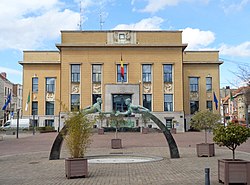
 Koekelberg's Municipal Hall seen from the Place Henri Vanhuffel/Henri Vanhuffelplein | |
| Coordinates: 50°52′N 04°20′E / 50.867°N 4.333°E | |
| Country | |
| Community | Flemish Community French Community |
| Region | Brussels-Capital |
| Arrondissement | Brussels-Capital |
| Government | |
| • Mayor | Ahmed Laaouej (PS) |
| • Governing party/ies | PS, Ecolo-Groen, Alternative Humaniste |
| Area | |
• Total | 1.18 km2 (0.46 sq mi) |
| Population (2020-01-01)[1] | |
• Total | 21,959 |
| • Density | 19,000/km2 (48,000/sq mi) |
| Postal codes | 1081 |
| NIS code | 21011 |
| Area codes | 02 |
| Website | www.koekelberg.be |
Koekelberg (French: [kukœlbɛʁ(ɡ)]; Dutch: [ˈkukəlˌbɛr(ə)x] ) is one of the 19 municipalities of the Brussels-Capital Region, Belgium. Located in the north-western part of the region, it is bordered by Berchem-Sainte-Agathe, Ganshoren, Jette, and Molenbeek-Saint-Jean. In common with all of Brussels' municipalities, it is legally bilingual (French–Dutch).
As of 1 January 2022[update], the municipality had a population of 22,023 inhabitants, the smallest in the region.[2] The total area is 1.18 km2 (0.46 sq mi), which gives a population density of 15,543/km2 (40,260/sq mi).[2]
The municipality is dominated by the National Basilica of the Sacred Heart (or Koekelberg Basilica), one of the largest Roman Catholic churches in the world.[3] Its main transportation hub are the connected Simonis and Elisabeth metro stations, served by the Brussels Intercommunal Transport Company (STIB/MIVB) system.
- ^ "Bevolking per gemeente op 1 januari 2020". Statbel.
- ^ a b "Koekelberg | IBSA". ibsa.brussels. Retrieved 5 January 2023.
- ^ Stéphany 2006, p. 63.


