| Lauriergracht | |
|---|---|
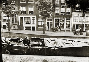
 Lauriergracht numbers 1 to 9, an 1895 photograph from the George Hendrik Breitner collection[1] | |
 | |
| Location | Amsterdam |
| Country | Netherlands |
| Coordinates | 52°22′16″N 4°52′48″E / 52.3712°N 4.8800°E |
The Lauriergracht (Dutch pronunciation: [lʌuˈriːrˌɣrɑxt]; literally "Laurel Canal"[2]) is one of the canals of Amsterdam, located in the Jordaan, west of the Grachtengordel.
- ^ Beeldbank 2019a.
- ^ Michelin 2001, p. 128.
