Back مابيلاري Arabic ম্যাপিলারি Bengali/Bangla Mapillary Danish Mapillary German Mapillary Spanish مپیلاری Persian Mapillary French Mapillary ID Mapillary Italian Mapillary Japanese
 | |
 | |
| Developer(s) | Meta Platforms, Inc. |
|---|---|
| Initial release | September 2013[1] |
| Operating system | |
| Available in | English |
| Type | Web mapping |
| License | CC BY-SA |
| Website | mapillary |
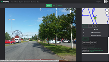
Mapillary is a service for sharing crowdsourced geotagged photos, developed by remote company Mapillary AB, based in Malmö, Sweden. Mapillary was launched in 2013 and acquired by Meta Platforms, Inc. in 2020. It offers street level imagery similar to Google Street View.
- ^ "Mapillary Founded date". www.mapillary.com. Retrieved 6 September 2018.