Back Melipeuco CEB Melipeuco German Melipeuco Spanish Melipeuco Basque ملیپئوکو Persian Melipeuco French Melipeuco Italian 멜리페우코 Korean Melipeuco Dutch Melipeuco Polish
Melipeuco | |
|---|---|
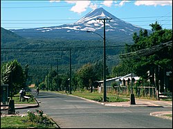
 Street in Melipeuco and Llaima Volcano in the background. | |
| Coordinates (city): 38°51′S 71°42′W / 38.850°S 71.700°W | |
| Country | Chile |
| Region | Araucanía |
| Province | Cautín |
| Government | |
| • Type | Municipality |
| • Alcalde | Eduardo Navarrete Fuentes (UDI) |
| Area | |
• Total | 1,107.3 km2 (427.5 sq mi) |
| Elevation | 461 m (1,512 ft) |
| Population (2012 Census)[3] | |
• Total | 5,590 |
| • Density | 5.0/km2 (13/sq mi) |
| • Urban | 2,333 |
| • Rural | 3,295 |
| Sex | |
| • Men | 2,906 |
| • Women | 2,722 |
| Time zone | UTC-4 (CLT[4]) |
| • Summer (DST) | UTC-3 (CLST[5]) |
| Area code | country 56 + city 45 |
| Website | www |
Melipeuco (Spanish pronunciation: [meliˈpewko]) is a town and commune (Spanish: comuna) in Chile, located at the foot of the Andes, in the Province of Cautín, Araucanía Region. Melipeuco is 12 km (7 mi) from the southern entrance of the Conguillío National Park. The Nevados de Sollipulli, an ice-filled volcanic caldera surrounded by numerous hot water springs and geysers, lie south of the town. Lake Carilafquén is also located in this area. At the edge of the Nevados de Sollipulli, at the Alpehue intersection 33 km (21 mi) away, there are several hot springs with water from 40 to 70 °C (104 to 158 °F), even in the middle of glacier blocks.
- ^ "Asociación Chilena de Municipalidades" (in Spanish). Archived from the original on 19 April 2011. Retrieved 23 February 2011.
- ^ "Municipality of Melipeuco" (in Spanish). Archived from the original on 15 September 2017. Retrieved 23 February 2011.
- ^ a b c "National Statistics Institute" (in Spanish). Retrieved 13 December 2010.
- ^ "Chile Time". WorldTimeZones.org. Archived from the original on 2007-09-11. Retrieved 2010-07-29.
- ^ "Chile Summer Time". WorldTimeZones.org. Archived from the original on 2007-09-11. Retrieved 2010-07-29.

