Back تيراينا ARZ Тэрайна Byelorussian Teraina Island CEB Teraina Czech Teraina German Τεράινα Greek Teraina Esperanto Teraina Spanish Teraina Estonian تراینا Persian
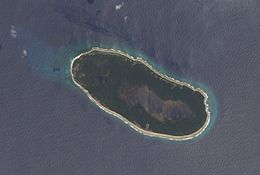
 Teraina in October 2006. North is on top. Notice the lake covering the southeast region of the island. The prevailing ocean current runs roughly left to right. | |
| Geography | |
|---|---|
| Location | North Pacific Ocean |
| Coordinates | 4°41′00″N 160°22′40″W / 4.68333°N 160.37778°W |
| Total islands | 1 |
| Area | 14.2 km2 (5.5 sq mi) |
| Highest elevation | 5 m (16 ft) |
| Island council | Teraina |
| Largest settlement | Tangkore |
| Demographics | |
| Population | 1,893 (2020) |
| Pop. density | 120.6/km2 (312.4/sq mi) |
| Languages | Gilbertese |
| Ethnic groups | I-Kiribati |
| Additional information | |
| Time zone | |
Teraina (written also Teeraina,[1] also known as Washington Island – these two names are constitutional[2]) is a coral atoll in the central Pacific Ocean and part of the Northern Line Islands which belong to Kiribati. Obsolete names of Teraina are New Marquesas, Prospect Island, and New York Island. The island is located approximately 4.71° North latitude and 160.76° West longitude. Teraina differs from most other atolls in the world in that it has a large freshwater lake (Washington Lake), an open lens, concealed within its luxuriant coconut palm forest; this is the only permanent freshwater lake in the whole of Kiribati.[3]
Measuring about 5.4 by 2.1 kilometres (3.4 by 1.3 miles) NW-SE and SW-NE, it has a land area of about 9.55 square kilometres (3.69 square miles);[3] its circumference is about 15 km (9 mi). The island is generally low-lying, with a maximum elevation ASL of about 5 meters (16 feet), while most of the island rises some three metres (10 feet) high; trees in the dense inland forest grow to several times this height however.[1] At the western end of the island is the capital, Tangkore (or Tengkore). There are (as at the 2020 Census) about 1,893 inhabitants,[1] making it the least-populated of the permanently inhabited Northern Line Islands. However, population density (177 per km2)[1] is three times as high as on Tabuaeran[1] and vastly more than on the much larger (300-plus km2) Kiritimati with its about 15 people/km2.[4]
There are two dirt roads around the island's perimeter – an outer (Beach Road) and an inner one (Ring Road). Transport inland is done by boat on artificial canals, rather uniquely for a Pacific island. A 21 meters (69 feet) navigation light tower and two radio masts stand near Tangkore.[5] What cannot be produced locally is shipped in about twice a year;[5] there is also some minor inter-island traffic by ship or boat. The old landing was at the western tip, but this was dangerous due to being exposed to surf breaking on the reef flats; it has been more recently replaced by a new and more easily accessible landing south of Tangkore, where the canal system feeds into the ocean.[5] A rough airstrip of some 1,000 meters (3,300 feet) length exists near Kaaitara. It may become temporarily unusable after heavy rains.
- ^ a b c d e "22. Teeraina" (PDF). Office of Te Beretitenti – Republic of Kiribati Island Report Series. 2012. Archived from the original (PDF) on 29 May 2017. Retrieved 28 April 2015.
- ^ POK (2007)
- ^ a b Teeb'aki in Scott (1993)
- ^ "20. Kiritimati" (PDF). Office of Te Beretitenti – Republic of Kiribati Island Report Series. 2012. Archived from the original (PDF) on 4 March 2016. Retrieved 28 April 2015.
- ^ a b c Resture (2004)


