Back اورمستين ARZ Urmston CEB Urmston Spanish Urmston Basque اورمستون Persian Urmston French Urmston Irish Urmston Italian Urmston (Lancashire) LLD Urmston Polish
| Urmston | |
|---|---|
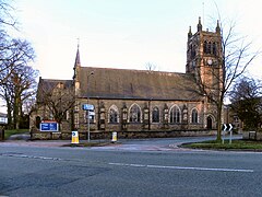
 St Clement's Church, Urmston | |
Location within Greater Manchester | |
| Population | 41,731 (2021 Census) |
| • Density | 10,881/sq mi (4,201/km2) |
| OS grid reference | SJ766947 |
| • London | 165 mi (266 km) SE |
| Metropolitan borough | |
| Metropolitan county | |
| Region | |
| Country | England |
| Sovereign state | United Kingdom |
| Post town | MANCHESTER |
| Postcode district | M17, M41 |
| Dialling code | 0161 |
| Police | Greater Manchester |
| Fire | Greater Manchester |
| Ambulance | North West |
| UK Parliament | |
Urmston /ˈɜːrmstən/ is a town in Trafford, Greater Manchester, England, which had a population of 41,731 at the 2021 Census. Historically in Lancashire, it is five miles (eight kilometres) southwest of Manchester city centre. The southern boundary is the River Mersey, with Stretford lying to the east and Flixton to the west. Davyhulme lies to the north of the town centre. Urmston covers an area of 4,799 acres (1,942 hectares).
The town has early medieval origins, and until the arrival of the railway in 1873 was a small farming community. The railway acted as a catalyst, transforming the town into a residence for the middle classes.
