Back ذائلة Arabic Virqa Azerbaijani Вирга Bulgarian ভিরগা Bengali/Bangla Virga Catalan Virga Czech Virga (Wolke) German Fantompluvo Esperanto Virga (meteorología) Spanish Virga Basque
This article needs additional citations for verification. (July 2024) |


| Part of a series on |
| Weather |
|---|
|
|
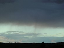
A virga, also called a dry storm, is an observable streak or shaft of precipitation that evaporates or sublimates before reaching the ground.[1] A shaft of precipitation that does not evaporate before reaching the ground is known in meteorology as a precipitation shaft. At high altitudes, precipitation falls mainly as ice crystals before melting and finally evaporating. That is often due to compressional heating, because air pressure increases closer to the ground. Virga is very common in deserts and temperate climates. In North America, it is commonly seen in the Western United States and the Canadian Prairies. It is also very common in the Middle East, Australia, and North Africa.
Virgae can cause varying weather effects because as rain is changed from liquid to vapor form it removes significant amounts of heat from the air due to water's high heat of vaporization. Precipitation falling into these cooling downdrafts may eventually reach the ground. In some instances these pockets of colder air can descend rapidly, creating a wet or dry microburst which can be extremely hazardous to aviation. Conversely, precipitation evaporating at high altitude can compressionally heat as it falls, and result in a gusty downburst which may substantially and rapidly warm the surface temperature. This fairly rare phenomenon, a heat burst, also tends to be of exceedingly dry air.
Virgae also have a role in seeding storm cells. That is because small particles from one cloud are blown into neighboring supersaturated air and act as nucleation particles for the next thunderhead cloud to begin forming.[citation needed]
- ^ Glossary of Meteorology. American Meteorological Society. 2000. ISBN 1-878220-34-9. Archived from the original on 2011-06-06.