Back ماناتوتو Arabic ماناتوتو ARZ Manatuto (kapital sa distrito) CEB Manatuto English Manatuto Esperanto Manatuto Spanish Manatuto French Manatuto ID Manatuto Italian 마나투투 Korean
| Manatuto | ||
|---|---|---|
|
| ||
| Koordinaten | 8° 31′ S, 126° 1′ O | |
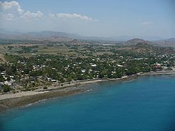
 Das Verwaltungsamt Manatuto mit der Stadt an der Nordküste | ||
| Basisdaten | ||
| Staat | Osttimor | |
| Gemeinde | Manatuto | |
| Verwaltungsamt | Manatuto | |
| ISO 3166-2 | TL-MT | |
| Suco | Aiteas, Ailili | |
| Höhe | 0 m | |
| Einwohner | 4655 (2022) | |
 Luftbild von Manatuto (2009)
| ||
Manatuto (Vila de Manatuto, Manaluto, tetum Manatutu) ist die Hauptstadt der osttimoresischen Gemeinde Manatuto und des Verwaltungsamts Manatuto. Der Name leitet sich von „Manatutu“ ab, dem Galoli-Wort für „pickende Vögel“.[1]
- ↑ Geoffrey Hull: The placenames of East Timor, in: Placenames Australia (ANPS): Newsletter of the Australian National Placenames Survey, Juni 2006, S. 6 & 7, ( vom 14. Februar 2017 im Internet Archive) abgerufen am 28. September 2014.
