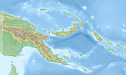
| UTC time | 1993-10-13 02:06:00 |
|---|---|
| ISC event | 202346 |
| USGS-ANSS | ComCat |
| Local date | October 13, 1993 |
| Magnitude | Mw 6.9 Mw 6.5 Mw 6.7 |
| Depth | 25.3 km (15.7 mi) |
| Epicenter | 5°53′20″S 146°01′12″E / 5.889°S 146.020°E[1] |
| Type | Thrust |
| Areas affected | Markham Valley, Papua New Guinea |
| Max. intensity | MMI IX (Violent)[2] |
| Landslides | 4,700 |
| Aftershocks | Many. Two >6.0 |
| Casualties | 60–65 dead, 200 injured[3] |
The 1993 Finisterre Range earthquakes began on October 13 with a Mw 6.9 mainshock,[2] followed by Mw 6.5 and 6.7 earthquakes.[4] These earthquakes struck beneath the Finisterre Range, north of Markham Valley in Morobe Province, Papua New Guinea. The complex earthquake sequence seriously damaged many villages in the rural Eastern Papua New Guinea region, generating landslides and killing at least 60 people.
- ^ "M 6.9 – 47 km NNE of Kainantu, Papua New Guinea". United States Geological Survey. Archived from the original on October 8, 2022. Retrieved October 11, 2021.
- ^ a b ISC (2015), ISC-GEM Global Instrumental Earthquake Catalogue (1900–2009), Version 2.0, International Seismological Centre, archived from the original on November 25, 2016, retrieved October 12, 2021
- ^ "Significant Earthquake Information". ngdc.noaa.gov. NOAA National Centers for Environmental Information. Archived from the original on October 29, 2021. Retrieved October 11, 2021.
- ^ "Significant Earthquakes – 1993". United States Geological Survey. Retrieved October 11, 2021.


