Back Atlantische Hurrikansaison 2022 German Temporada de huracanes en el Atlántico de 2022 Spanish Vuoden 2022 Atlantin hurrikaanikausi Finnish Saison cyclonique 2022 dans l'océan Atlantique nord French Stagione degli uragani atlantici del 2022 Italian 2022년 북대서양 허리케인 Korean Atlantisch orkaanseizoen 2022 Dutch Temporada de furacões no Atlântico de 2022 Portuguese 2022 Atlantic hurricane season SIMPLE ฤดูพายุเฮอริเคนแอตแลนติก พ.ศ. 2565 Thai
| 2022 Atlantic hurricane season | |
|---|---|
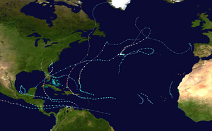
 Season summary map | |
| Seasonal boundaries | |
| First system formed | June 5, 2022 |
| Last system dissipated | November 11, 2022 |
| Strongest storm | |
| By maximum sustained winds | Ian |
| • Maximum winds | 160 mph (260 km/h) (1-minute sustained) |
| • Lowest pressure | 937 mbar (hPa; 27.67 inHg) |
| By central pressure | Fiona |
| • Maximum winds | 140 mph (220 km/h) (1-minute sustained) |
| • Lowest pressure | 931 mbar (hPa; 27.49 inHg) |
| Seasonal statistics | |
| Total depressions | 16 |
| Total storms | 14 |
| Hurricanes | 8 |
| Major hurricanes (Cat. 3+) | 2 |
| Total fatalities | 304 total |
| Total damage | > $117.708 billion (2022 USD) (Fourth-costliest tropical cyclone season on record[1]) |
| Related articles | |
The 2022 Atlantic hurricane season was a destructive and deadly Atlantic hurricane season. Despite having an average number of named storms and below average amount of major hurricanes,[nb 1] it became the fourth-costliest Atlantic hurricane season on record, behind only 2005, 2024 and 2017 mostly due to Hurricane Ian. The season officially began on June 1, and ended on November 30. These dates, adopted by convention, historically describe the period in each year when most subtropical or tropical cyclogenesis occurs in the Atlantic Ocean.[3] This year's first Atlantic named storm, Tropical Storm Alex, developed five days after the start of the season, making this the first season since 2014 not to have a pre-season named storm.
Two systems developed on July 1. Tropical Storm Bonnie formed and made landfall near the Costa Rica–Nicaragua border. It then crossed over into the Pacific basin, becoming the first to survive the crossover from the Atlantic to the Pacific since Hurricane Otto in 2016. Also, Tropical Storm Colin formed abruptly and made landfall in South Carolina, before quickly weakening and dissipating the next day. Following this activity, tropical cyclogenesis was suppressed across the basin for several weeks by a combination of increased wind shear and the presence of the Saharan Air Layer. This stopped all tropical cyclogenesis in August, the first season to do so since 1997, and the first during a La Niña. After an almost 60-day lull in tropical cyclone activity, hurricanes Danielle and Earl formed on September 1 and 3 respectively, with Danielle becoming the season's first hurricane. The last season to have its first hurricane develop this late was 2013.
Activity then increased tremendously towards the end of September as four named storms formed in quick succession. Among them, Hurricane Fiona became the season's first major hurricane on September 20, which is about three weeks later than when the first one typically forms.[4] As an extratropical cyclone it became the strongest storm in Canadian history, as measured by atmospheric pressure, and caused significant damage in Atlantic Canada. Hurricane Ian then became the second major hurricane of the season on September 27 and the only Category 5 of the season on September 28 and inflicted an estimated $113.1 billion in damage to western Cuba, Southwestern and Central Florida, and the Carolinas. Hurricane Julia formed in early October and became the second storm of the season to cross over into the Pacific basin intact after traversing Nicaragua, making this season the first to have more than one crossover system since 1996. The last storm in the season, Hurricane Nicole, made landfall on the coasts of the Bahamas and Florida. It was the first November hurricane to make landfall in Florida since Kate in 1985, and caused about $1 billion in damage in areas devastated by Ian six weeks earlier. Tropical cyclones during this season collectively caused at least 304 deaths and more than $117.7 billion in damage, making it one of the costliest seasons on record.
Most forecasting agencies anticipated a well-above average season due to warmer-than-normal sea surface temperatures and a favorable El Niño–Southern Oscillation pattern, limiting the chances of El Niño developing. While conducive conditions such as warmer sea surface temperatures and a La Niña came to fruition, the unfavorable wind shear pattern with drier air and Saharan Air Layer suppressed tropical cyclogenesis through most of July and the entirety of August, with the latter typically being among the most active climatologically.
- ^ 2022 Hurricane Season Ends But Was the Third-Costliest on Record, Thanks to Ian Archived September 3, 2023, at the Wayback Machine, Insurance Journal, December 2, 2022
- ^ Monthly Tropical Weather Summary for November 2022 (Report). Miami, Florida: National Hurricane Center. December 1, 2022. Archived from the original on December 2, 2022. Retrieved December 2, 2022.
- ^ "Hurricanes Frequently Asked Questions". Miami, Florida: NOAA Atlantic Oceanographic and Meteorological Laboratory. June 1, 2021. Archived from the original on September 17, 2021. Retrieved January 30, 2022.
- ^ Masters, Jeff; Henson, Bob (September 20, 2022). "Cat 3 Fiona rakes Turks and Caicos; Disturbance 98L approaches Caribbean". New Haven, Connecticut: Yale climate Connections. Archived from the original on September 20, 2022. Retrieved September 20, 2022.
Cite error: There are <ref group=nb> tags on this page, but the references will not show without a {{reflist|group=nb}} template (see the help page).