A8 (numerous constituent roads) | |
|---|---|
 | |
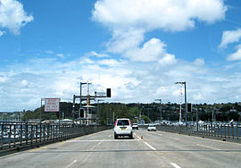
| Driving southbound over the Spit Bridge | |
| Coordinates |
|
| General information | |
| Type | Road |
| Length | 22.8 km (14 mi)[1] |
| Gazetted | August 1928[2] |
| Route number(s) | |
| Former route number |
|
| Major junctions | |
| Northeast end | Pittwater Road Mona Vale, Sydney |
| |
| Southwest end | Falcon Street North Sydney |
| Location(s) | |
| Major suburbs | Narrabeen, Collaroy, Dee Why, Brookvale, Balgowlah, Seaforth, Mosman, Cremorne |
| Highway system | |
| ---- | |
The A8 is a route designation of a major metropolitan arterial route through suburban north-eastern Sydney. This name covers a few consecutive roads and is widely known to most drivers, but the entire allocation is also known – and signposted – by the names of its constituent parts: Pittwater Road, Condamine Street, Burnt Bridge Creek Deviation, Manly Road, Spit Road and Military Road.
The A8 is a major transport link through the Northern Beaches district of Sydney, forming one of only three road connections between the Northern Beaches area and the rest of Sydney (the others being routes A3 and A38). The crossing of Middle Harbour over the Spit Bridge has become infamous as one of the most congested road links in the city, compounded by the regular opening of the bridge to allow boats to pass by.
- ^ "A8 road" (Map). Google Maps. Retrieved 17 August 2022.
- ^ "Main Roads Act, 1924-1927". Government Gazette of the State of New South Wales. No. 110. National Library of Australia. 17 August 1928. pp. 3814–20. Archived from the original on 3 August 2022. Retrieved 1 August 2022.

