Back التقسيم الإداري في المملكة المتحدة Arabic Böyük Britaniyanın inzibati bölgüsü Azerbaijani Адміністрацыйны падзел Вялікабрытаніі Byelorussian Административно деление на Обединеното кралство Bulgarian Administrativní dělení Spojeného království Czech Storbritanniens nationer efter areal Danish Verwaltungsgliederung des Vereinigten Königreichs German Erresuma Batuaren banaketa administratiboa Basque جغرافیای اداری پادشاهی متحد (بریتانیا) Persian Yhdistyneen kuningaskunnan osat Finnish


The administrative geography of the United Kingdom is complex, multi-layered and non-uniform. The United Kingdom, a sovereign state to the northwest of continental Europe, consists of England, Northern Ireland, Scotland and Wales. For local government in the United Kingdom, England, Northern Ireland, Scotland and Wales each have their own system of administrative and geographic demarcation. Consequently, there is "no common stratum of administrative unit encompassing the United Kingdom".[1]
Because there is no written document that comprehensively encompasses the British constitution, and owing to a convoluted history of the formation of the United Kingdom, a variety of terms are used to refer to its constituent parts, which are sometimes called the four countries of the United Kingdom.[2] The four are sometimes collectively referred to as the Home Nations, particularly in sporting contexts. Although the four countries are important for legal and governmental purposes, they are not comparable to administrative subdivisions of most other countries.
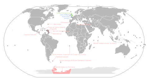
The United Kingdom also contains 17 dependent territories which aren't officially a part of the UK but are represented by it in places like the UN.
Historically, the subnational divisions of the UK have been the county[3] and the ecclesiastical parish, while following the emergence of a unified parliament of the United Kingdom, the ward and constituency have been pan-UK political subdivisions. More contemporary divisions include Lieutenancy areas and the statistical territories defined with the modern ITL (formerly NUTS) and ISO 3166-2:GB systems.
- ^ United Nations Economic and Social Council (August 2007). "Ninth United Nations Conference on the standardization of Geographical Names" (PDF). unstats.un.org. Archived from the original (PDF) on 30 October 2008. Retrieved 21 October 2008.
- ^ Scottish Parliament. "Your Scotland questions; Is Scotland a country?". scottish.parliament.uk. Archived from the original on 21 June 2008. Retrieved 1 August 2008.
As the UK has no written constitution in the usual sense, constitutional terminology is fraught with difficulties of interpretation and it is common usage nowadays to describe the four constituent parts of the UK (Scotland, England, Wales and Northern Ireland) as "countries".
- ^ Bryne, T., Local Government in Britain, (1994)