Back جهاز متقدم لقياس الانبعاث الحراري والانعكاس الإشعاعي Arabic ASTER Catalan ASTER German رادیومتر پیشرفته فضابرد بازتابی و گسیل گرمایی Persian Advanced Spaceborne Thermal Emission and Reflection Radiometer ID Advanced Spaceborne Thermal Emission and Reflection Radiometer Italian ASTER (リモートセンシング) Japanese ASTER Portuguese

The Advanced Spaceborne Thermal Emission and Reflection Radiometer (ASTER) is a Japanese remote sensing instrument onboard the Terra satellite launched by NASA in 1999. It has been collecting data since February 2000.

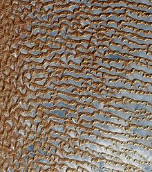
ASTER provides high-resolution images of Earth in 14 different bands of the electromagnetic spectrum, ranging from visible to thermal infrared light. The resolution of images ranges between 15 and 90 meters. ASTER data is used to create detailed maps of surface temperature of land, emissivity, reflectance, and elevation.[1]
In April 2008, the SWIR detectors of ASTER began malfunctioning and were publicly declared non-operational by NASA in January 2009. All SWIR data collected after 1 April 2008 has been marked as unusable.[2]
The ASTER Global Digital Elevation Model (GDEM) is available at no charge to users worldwide via electronic download.[3]
As of 2 April 2016, the entire catalogue of ASTER image data became publicly available online at no cost.[4] It can be downloaded with a free registered account from either NASA's Earth Data Search delivery system[5] or from the USGS Earth Explorer delivery system.[6]
- ^ Wigglesworth, Alex (6 November 2019). "Satellite image shows Kincade fire burn scar". Los Angeles Times. Retrieved 7 November 2019.
- ^ "LP DAAC - ASTER User Advisory (updated: January 14, 2009)".
- ^ "METI and NASA Release Version 2 ASTER Global DEM". U.S. Geological Survey / NASA LP DAAC. Archived from the original on 21 December 2013. Retrieved 21 December 2013.
- ^ "NASA, Japan Make ASTER Earth Data Available At No Cost | NASA". 31 March 2016.
- ^ "Earthdata Search".
- ^ "EarthExplorer".