Back مقاطعة ألاماكي (آيوا) Arabic Allamakee County, Iowa BAR Аламаки (окръг, Айова) Bulgarian আলামাকী কাউন্টি, আইৱা BPY Allamakee Gông (Iowa) CDO Алламаки (гуо, Айова) CE Allamakee County CEB Allamakee County, Iowa Welsh Allamakee County German Kantono Allamakee Esperanto
Allamakee County | |
|---|---|
 | |
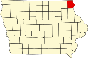
 Location within the U.S. state of Iowa | |
 Iowa's location within the U.S. | |
| Coordinates: 43°17′12″N 91°22′27″W / 43.286666666667°N 91.374166666667°W | |
| Country | |
| State | |
| Founded | 1847 |
| Seat | Waukon |
| Largest city | Waukon |
| Area | |
• Total | 659 sq mi (1,710 km2) |
| • Land | 639 sq mi (1,660 km2) |
| • Water | 20 sq mi (50 km2) 3.0% |
| Population (2020) | |
• Total | 14,061 |
• Estimate (2023) | 14,074 |
| • Density | 21/sq mi (8.2/km2) |
| Time zone | UTC−6 (Central) |
| • Summer (DST) | UTC−5 (CDT) |
| Congressional district | 2nd |
| Website | allamakeecounty |
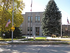
Allamakee County (/ˈæləməˌki/) is the northeasternmost county in the U.S. state of Iowa. As of the 2020 census, the population was 14,061.[1] Its county seat is Waukon.[2]
- ^ "2020 Census State Redistricting Data". census.gov. United states Census Bureau. Retrieved August 12, 2021.
- ^ "Find a County". National Association of Counties. Archived from the original on May 31, 2011. Retrieved June 7, 2011.