Back Alpine-Nationalpark German Parque nacional Alpino Spanish پارک ملی آلپاین Persian Parc national alpin French ആൽപൈൻ ദേശീയോദ്യാനം Malayalam Park Narodowy Alpine Polish Алпайн (национальный парк) Russian Alpine National Park Swedish
| Alpine National Park Victoria | |
|---|---|
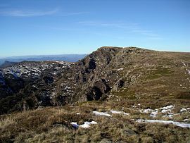
 The summit of Mount Howitt taken from West Peak | |
 | |
| Nearest town or city | Omeo |
| Coordinates | m 37°20′15″S 146°45′24″E / 37.33750°S 146.75667°E |
| Established | 1989 |
| Area | 6,474 km2 (2,499.6 sq mi)[1] |
| Managing authorities | Parks Victoria |
| Website | Alpine National Park |
| See also | Protected areas of Victoria |
The Alpine National Park is a national park located in the Central Highlands and Alpine regions of Victoria, Australia. The 646,000-hectare (1,600,000-acre) national park is located northeast of Melbourne. It is the largest National Park in Victoria, and covers much of the higher areas of the Great Dividing Range in Victoria, including Victoria's highest point, Mount Bogong at 1,986 metres (6,516 ft)[2] and the associated subalpine woodland and grassland of the Bogong High Plains. The park's north-eastern boundary is along the border with New South Wales, where it abuts the Kosciuszko National Park.[3] On 7 November 2008 the Alpine National Park was added to the Australian National Heritage List as one of eleven areas constituting the Australian Alps National Parks and Reserves.[1]
- ^ a b "Australian Alps National Parks and Reserves: Statement of significance". Australian Heritage Database. Department of the Environment, Australian Government. 7 November 2008. Retrieved 9 August 2014.
- ^ Cite error: The named reference
pbbogongwas invoked but never defined (see the help page). - ^ "Alpine National Park". Australian Alps National Parks. Commonwealth of Australia. 2013. Retrieved 9 August 2014.
