Back نهر اندروسكوجين ARZ Androscoggin River (suba sa Tinipong Bansa, Sagadahoc County) CEB Андроскоггин (юханшыв) CV Androscoggin River Danish Androscoggin River German Río Androscoggin Spanish Rivière Androscoggin French Androscoggin Italian Androskoginas Lithuanian Androscoggin (rzeka) Polish
| Androscoggin River Aləssíkαntekʷ | |
|---|---|
 The Androscoggin flowing past Lewiston, Maine | |
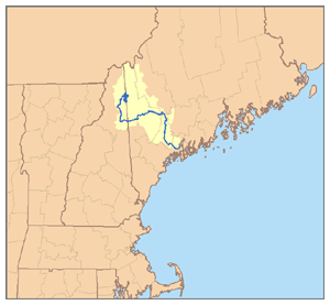
 Map of the Androscoggin River watershed | |
| Location | |
| Country | United States |
| State | Maine, New Hampshire |
| Cities | Auburn, Lewiston, Berlin |
| Physical characteristics | |
| Source | Umbagog Lake |
| • location | Coos County, New Hampshire |
| • coordinates | 44°46′59″N 71°3′41″W / 44.78306°N 71.06139°W[1] |
| • elevation | 1,243 ft (379 m)[2] |
| Mouth | Kennebec River |
• location | Merrymeeting Bay, Sagadahoc County, Maine |
• coordinates | 43°57′2″N 69°52′39″W / 43.95056°N 69.87750°W[1] |
• elevation | 0 ft (0 m)[3] |
| Length | 164 mi (264 km)[4] |
| Basin size | 3,450 sq mi (8,900 km2)[4] |
| Discharge | |
| • location | Auburn[5] |
| • average | 6,174 cu ft/s (174.8 m3/s)[5] |
| • minimum | 340 cu ft/s (9.6 m3/s) |
| • maximum | 135,000 cu ft/s (3,800 m3/s) |
| Discharge | |
| • location | mouth[4] |
| • average | 6,482 cu ft/s (183.5 m3/s)[4] |
| Basin features | |
| Tributaries | |
| • left | Sunday River, Dead River |
| • right | Magalloway River, Peabody River, Wild River |
Androscoggin River | ||||||||||||||||||||||||||||||||||||||||||||||||||||||||||||||||||||||||||||||||||||||||||||||||||||||||||||||||||||||||||||||||||||||||||||||||||||||||||||||||||||||||||||||||||||||||||||||||||||||||||||||||||||||||||||||||||||||||||||||||||||||||||||||||||||||||||||||||||||||||||||||||||||||||||||||||||||||||||||||||||||||||||||||||||||||||||||||||||||||||||||||||||||||||||||||||||||||||||||||||||||||||||||||||||||||||||||||||||||||||||||||||||||||||||||||||||||||||||||||||||||||||||||||||||||||||||||||||||||||||||||||||||||
|---|---|---|---|---|---|---|---|---|---|---|---|---|---|---|---|---|---|---|---|---|---|---|---|---|---|---|---|---|---|---|---|---|---|---|---|---|---|---|---|---|---|---|---|---|---|---|---|---|---|---|---|---|---|---|---|---|---|---|---|---|---|---|---|---|---|---|---|---|---|---|---|---|---|---|---|---|---|---|---|---|---|---|---|---|---|---|---|---|---|---|---|---|---|---|---|---|---|---|---|---|---|---|---|---|---|---|---|---|---|---|---|---|---|---|---|---|---|---|---|---|---|---|---|---|---|---|---|---|---|---|---|---|---|---|---|---|---|---|---|---|---|---|---|---|---|---|---|---|---|---|---|---|---|---|---|---|---|---|---|---|---|---|---|---|---|---|---|---|---|---|---|---|---|---|---|---|---|---|---|---|---|---|---|---|---|---|---|---|---|---|---|---|---|---|---|---|---|---|---|---|---|---|---|---|---|---|---|---|---|---|---|---|---|---|---|---|---|---|---|---|---|---|---|---|---|---|---|---|---|---|---|---|---|---|---|---|---|---|---|---|---|---|---|---|---|---|---|---|---|---|---|---|---|---|---|---|---|---|---|---|---|---|---|---|---|---|---|---|---|---|---|---|---|---|---|---|---|---|---|---|---|---|---|---|---|---|---|---|---|---|---|---|---|---|---|---|---|---|---|---|---|---|---|---|---|---|---|---|---|---|---|---|---|---|---|---|---|---|---|---|---|---|---|---|---|---|---|---|---|---|---|---|---|---|---|---|---|---|---|---|---|---|---|---|---|---|---|---|---|---|---|---|---|---|---|---|---|---|---|---|---|---|---|---|---|---|---|---|---|---|---|---|---|---|---|---|---|---|---|---|---|---|---|---|---|---|---|---|---|---|---|---|---|---|---|---|---|---|---|---|---|---|---|---|---|---|---|---|---|---|---|---|---|---|---|---|---|---|---|---|---|---|---|---|---|---|---|---|---|---|---|---|---|---|---|---|---|---|---|---|---|---|---|---|---|---|---|---|---|---|---|---|---|---|---|---|---|---|---|---|---|---|---|---|---|---|---|---|---|---|---|---|---|---|---|---|---|---|---|---|---|---|---|---|---|---|---|---|---|---|---|---|---|---|---|---|---|---|---|---|---|---|---|---|---|---|---|---|---|---|---|---|---|---|---|---|---|---|---|---|---|---|---|---|---|---|---|---|---|---|---|---|
| ||||||||||||||||||||||||||||||||||||||||||||||||||||||||||||||||||||||||||||||||||||||||||||||||||||||||||||||||||||||||||||||||||||||||||||||||||||||||||||||||||||||||||||||||||||||||||||||||||||||||||||||||||||||||||||||||||||||||||||||||||||||||||||||||||||||||||||||||||||||||||||||||||||||||||||||||||||||||||||||||||||||||||||||||||||||||||||||||||||||||||||||||||||||||||||||||||||||||||||||||||||||||||||||||||||||||||||||||||||||||||||||||||||||||||||||||||||||||||||||||||||||||||||||||||||||||||||||||||||||||||||||||||||
The Androscoggin River (Abenaki: Ammoscongon)[6] is a river in the U.S. states of Maine and New Hampshire, in northern New England. It is 178 miles (286 km)[7] long and joins the Kennebec River at Merrymeeting Bay in Maine before its water empties into the Gulf of Maine on the Atlantic Ocean. Its drainage basin is 3,530 square miles (9,100 km2) in area. The name "Androscoggin" comes from the Eastern Abenaki term Ammoscongon, which referred to the entire portion of the river north of the Great Falls in Lewiston, Maine.[6] The Anglicization of the Abenaki term is likely an analogical contamination with the colonial governor Edmund Andros.[8][9]
- ^ a b U.S. Geological Survey Geographic Names Information System: Androscoggin River, USGS GNIS.
- ^ Google Earth elevation for GNIS source coordinates.
- ^ Google Earth elevation for GNIS mouth coordinates.
- ^ a b c d "Androscoggin Watershed". MaineRivers.org. Archived from the original on March 3, 2016. Retrieved December 14, 2016.
- ^ a b Water Resources Data - Maine, Water Year 2005, USGS Water Data Reports for the United States, 2005.
- ^ a b "Pere Pole deposition, 1792". Maine Memory Network. Retrieved January 4, 2024.
- ^ U.S. Geological Survey. National Hydrography Dataset high-resolution flowline data. The National Map Archived March 29, 2012, at the Wayback Machine, accessed June 30, 2011
- ^ Bright, William (2004). Native American placenames of the United States. University of Oklahoma Press. p. 39. ISBN 978-0-8061-3598-4. Retrieved April 11, 2011.
- ^ Dean R. Snow, "Eastern Abenaki", in Handbook of North American Indians, ed. Bruce G. Trigger (Washington, D.C.: Smithsonian Institution, 1978), 15:146.