Back Anguilla (eiland) Afrikaans Anguilla ALS አንጒላ Amharic Anguila AN Anguilla ANG अंगुइला ANP أنغويلا Arabic انجويلا ARZ Anguila (dependencia) AST Angilya Azerbaijani
18°13′38″N 63°02′56″W / 18.22723°N 63.04899°W
Anguilla | |
|---|---|
| Motto: "Unity, Strength and Endurance" | |
| Anthem: "God Save the King" | |
| National song: "God Bless Anguilla" | |
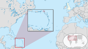
 Location of Anguilla (red) | |
 | |
| Sovereign state | |
| English control | 1667 |
| Federation with Saint Kitts and Nevis | 1871 |
| Secession and independence | 12 July 1967 |
| British control restored | 18 March 1969 |
| Capital and largest city | The Valley 18°13′15″N 63°03′06″W / 18.22083°N 63.05167°W |
| Official languages | English |
| Ethnic groups (2011)[1] | |
| Demonym(s) | Anguillan |
| Government | |
• Monarch | Charles III |
• Governor | Julia Crouch |
• Deputy Governor | Perin A. Bradley |
• Premier | Ellis Webster |
| Legislature | House of Assembly |
| Government of the United Kingdom | |
• Minister | Stephen Doughty |
| Area | |
• Total | 91 km2 (35 sq mi) |
• Water (%) | negligible |
| Highest elevation | 73 m (240 ft) |
| Population | |
• 2021 estimate | 15,753[2][3] (not ranked) |
• 2011 census | 13,452 |
• Density | 132/km2 (341.9/sq mi) (not ranked) |
| GDP (PPP) | 2014 estimate |
• Total | $311 million[4] |
• Per capita | $29,493 |
| GDP (nominal) | 2020 estimate |
• Total | US$307,000,000[5] |
| Currency | Eastern Caribbean dollar (XCD) |
| Time zone | UTC–4 (AST) |
| Date format | dd/mm/yyyy |
| Driving side | left |
| Calling code | +1-264 |
| UK postcode | AI-2640 |
| ISO 3166 code | AI |
| Internet TLD | .ai |
| Website | gov.ai |
Preview warning: Page using Template:Infobox political division with unknown parameter "status"
Anguilla (/æŋˈɡwɪlə/ ang-GWIL-ə) is a British Overseas Territory in the Caribbean.[6] It is one of the most northerly of the Leeward Islands in the Lesser Antilles, lying east of Puerto Rico and the Virgin Islands and directly north of Saint Martin.[7] The territory consists of the main island of Anguilla, approximately 16 miles (26 kilometres) long by 3 miles (5 km) wide at its widest point, together with a number of much smaller islands and cays with no permanent population. The territory's capital is The Valley.[8] The total land area of the territory is 35 square miles (91 km2),[9] with a population of approximately 15,753[2][3] (2021).
- ^ "Anguilla". The World Factbook (2024 ed.). Central Intelligence Agency. Retrieved 20 September 2019. (Archived 2019 edition.)
- ^ a b "World Population Prospects 2022". United Nations Department of Economic and Social Affairs, Population Division. Retrieved 17 July 2022.
- ^ a b "World Population Prospects 2022: Demographic indicators by region, subregion and country, annually for 1950-2100" (XSLX) ("Total Population, as of 1 July (thousands)"). United Nations Department of Economic and Social Affairs, Population Division. Retrieved 17 July 2022.
- ^ "UN Data". Archived from the original on 30 December 2016. Retrieved 7 January 2017.
- ^ UNCTAD. "UNCTADstat - General Profile: Anguilla". UNCTADstat. Archived from the original on 9 August 2021. Retrieved 9 August 2021.
- ^ "Anguilla". The World Factbook (2024 ed.). Central Intelligence Agency. Retrieved 31 October 2009. (Archived 2009 edition.)
- ^ "Encyclopedia Britannica – Anguilla". Archived from the original on 7 August 2022. Retrieved 12 July 2019.
- ^ "Anguilla". The World Factbook (2024 ed.). Central Intelligence Agency. Retrieved 11 July 2019. (Archived 2019 edition.)
- ^ "Anguilla Facts". Government of Anguilla. Archived from the original on 17 May 2013. Retrieved 1 January 2013.

