Back أباتين Arabic Апатин Bulgarian Apatin BS Апатин CE Apatin CEB Apatin Czech Apatin Danish Apatin German Apatin Esperanto Apatin Spanish
Apatin
Abthausen | |
|---|---|
Town and municipality | |
|
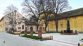
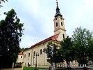
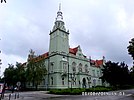
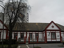
From top: Freedom Square, Our Lady Catholic Church, Town Hall, Apatin Brewery | |
 Location of the municipality of Apatin within Serbia | |
| Coordinates: 45°40′N 18°59′E / 45.667°N 18.983°E | |
| Country | |
| Province | |
| Region | Bačka (Podunavlje) |
| District | West Bačka |
| Municipality | Apatin |
| Settlements | 5 |
| Government | |
| • Municipal president | Dubravka Korać (SNS) |
| Area | |
| • Town | 112.93 km2 (43.60 sq mi) |
| • Municipality | 379.00 km2 (146.33 sq mi) |
| Elevation | 82 m (269 ft) |
| Population (2022 census)[3] | |
| • Town | 14,613 |
| • Town density | 130/km2 (340/sq mi) |
| • Municipality | 23,155 |
| • Municipality density | 61/km2 (160/sq mi) |
| Time zone | UTC+1 (CET) |
| • Summer (DST) | UTC+2 (CEST) |
| Postal code | 25260 |
| Area code | +381 25 |
| Car plates | SO |
| Website | www |
Apatin (Serbian Cyrillic: Апатин, Hungarian: Apatin, Croatian: Apatin) is a town and municipality located in the West Bačka District of the autonomous province of Vojvodina, Serbia. As of 2022 census, the population of the town is 14,613, while the municipality has 23,155 inhabitants.
- ^ "Municipalities of Serbia, 2006". Statistical Office of Serbia. Retrieved 2010-11-28.
- ^ "Насеља општине Апатин" (PDF). stat.gov.rs (in Serbian). Statistical Office of Serbia. Archived from the original (PDF) on 6 March 2016. Retrieved 24 October 2019.
- ^ "2022 Census of Population, Households and Dwellings: Ethnicity (data by municipalities and cities)" (PDF). Statistical Office of Republic Of Serbia, Belgrade. April 2023. ISBN 978-86-6161-228-2. Retrieved 2023-04-30.


