Back مقاطعة أرتشوليتا (كولورادو) Arabic Archuleta County, Colorado BAR Арчэліта (акруга) Byelorussian Арчулета Bulgarian আরচুলেটা কাউন্টি, কলোরাডো BPY Archuleta Gông (Colorado) CDO Арчулета (гуо, Колорадо) CE Archuleta County CEB Archuleta County Czech Archuleta County, Colorado Welsh
Archuleta County | |
|---|---|
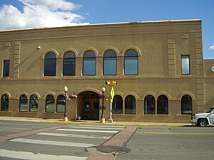
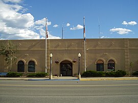
 Archuleta County Courthouse | |
 Location within the U.S. state of Colorado | |
 Colorado's location within the U.S. | |
| Coordinates: 37°11′N 107°03′W / 37.19°N 107.05°W | |
| Country | |
| State | |
| Founded | April 14, 1885 |
| Named for | Antonio D. Archuleta |
| Seat | Pagosa Springs |
| Largest town | Pagosa Springs |
| Area | |
| • Total | 1,356 sq mi (3,510 km2) |
| • Land | 1,350 sq mi (3,500 km2) |
| • Water | 5.3 sq mi (14 km2) 0.4% |
| Population (2020) | |
| • Total | 13,359 |
| • Density | 9.9/sq mi (3.8/km2) |
| Time zone | UTC−7 (Mountain) |
| • Summer (DST) | UTC−6 (MDT) |
| Congressional district | 3rd |
| Website | www |

Archuleta County is a county located in the U.S. state of Colorado. As of the 2020 census, the population was 13,359.[1] The county seat and the only incorporated municipality in the county is Pagosa Springs.[2]
- ^ Cite error: The named reference
:0was invoked but never defined (see the help page). - ^ "Find a County". National Association of Counties. Archived from the original on May 31, 2011. Retrieved June 7, 2011.