Back حادثة أرميرو المأسوية Arabic Tragèdia d'Armero Catalan Trychineb Armero Welsh Tragedia de Armero Spanish فاجعه آرمرو Persian Armeron onnettomuus Finnish Éruption du Nevado del Ruiz en 1985 French Tragóid Armero Irish Traxedia de Armero Galician Tragedi Armero ID
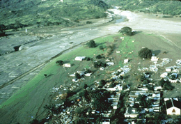
 Lahars covering the town of Armero | |
| Date | November 13, 1985 |
|---|---|
| Location | Nevado del Ruiz, Tolima, Colombia |
| Coordinates | 04°57′48″N 74°54′20″W / 4.96333°N 74.90556°W |
| Type | Lahars |
| Cause | Volcanic eruption |
| Deaths | 23,000+ |
| Non-fatal injuries | 5,000 (approximate) |
| Missing | 3,300 |
| Property damage | $1 billion |
The Armero tragedy (Spanish: Tragedia de Armero [tɾaˈxeðja ðe aɾˈmeɾo]) occurred following the eruption of the Nevado del Ruiz stratovolcano in Tolima, Colombia, on November 13, 1985. The volcano's eruption after 69 years of dormancy caught nearby towns unprepared, even though volcanological organizations had warned the government to evacuate the area after they detected volcanic activity two months earlier.[1]
As pyroclastic flows erupted from the volcano's crater, they melted the mountain's glaciers, sending four enormous lahars (volcanically induced mudflows, landslides, and debris flows) down its slopes at 50 km/h (30 mph). The lahars picked up speed in gullies and engulfed the town of Armero, killing more than 20,000 of its almost 29,000 inhabitants.[2] Casualties in other towns, particularly Chinchiná, brought the overall death toll to 23,000. Footage and photographs of Omayra Sánchez, a young victim of the disaster, were published around the world. Other photographs of the lahars and the impact of the disaster captured attention worldwide and led to controversy over the degree to which the Colombian government was responsible for the disaster. A banner at a mass funeral in Ibagué read, "The volcano didn't kill 22,000 people. The government killed them."
The relief efforts were hindered by the composition of the mud, which made it nearly impossible to move through without becoming stuck. By the time relief workers reached Armero twelve hours after the eruption, many of the victims with serious injuries were dead. The relief workers were horrified by the landscape of fallen trees, disfigured human bodies, and piles of debris from entire houses. This was the second-deadliest volcanic disaster of the 20th century, surpassed only by the 1902 eruption of Mount Pelée, and is the fourth-deadliest volcanic event recorded since 1500.
The event was a foreseeable catastrophe exacerbated by the populace's unawareness of the volcano's destructive history; geologists and other experts had warned authorities and media outlets about the danger in the weeks and days leading up to the eruption. Hazard maps for the vicinity were prepared but poorly distributed. On the day of the eruption, several evacuation attempts were made, but a severe storm restricted communications. Many victims stayed in their houses as they had been instructed, believing that the eruption had ended. The noise from the storm may have prevented many from hearing the sounds of the eruption until it was too late.
Nevado del Ruiz has erupted several times since 1985, and continues to threaten up to 500,000 people living along the Combeima, Chinchiná, Coello-Toche, and Guali river valleys. A lahar (or group of lahars) similar in size to the 1985 event might travel as far as 100 km (60 mi) from the volcano and could be triggered by a small eruption. To counter this threat, the Colombian government established a specialized office which administers the national system for identification, prevention, preparedness and management of natural disasters, the National Unit for Management of Disasters Risk (Sistema Nacional de Gestión del Riesgo de Desastres).[3] The United States Geological Survey also created the Volcano Disaster Assistance Program and the Volcano Crisis Assistance Team, which evacuated roughly 75,000 people from the area around Mount Pinatubo before its 1991 eruption. All Colombian counties, by law, have a territorial plan that includes the identification of natural threats, treatment for building permits and preparedness for the prevention and management of natural disasters through planning programs which have helped save lives in many natural disasters since Armero's tragedy.
In 1988, three years after the eruption, Stanley Williams of Louisiana State University stated that, "With the possible exception of Mount St. Helens in the state of Washington, no other volcano in the Western Hemisphere is being watched so elaborately" as Nevado del Ruiz. Communities living near the volcano have become wary of volcanic activity: when it erupted in 1989, more than 2,300 people living around it were evacuated.
- ^ "Nevado del Ruiz". Global Volcanism Program. Smithsonian Institution. Retrieved June 1, 2010.
- ^ Schuster, Robert L. and Highland, Lynn M. (2001). Socioeconomic and Environmental Impacts of Landslides in the Western Hemisphere Archived April 13, 2012, at the Wayback Machine, U.S. Geological Survey Open-File Report 01-0276. Also previously published in the Proceedings of the Third Panamerican Symposium on Landslides, July 29 to August 3, 2001, Cartagena, Colombia. Castaneda Martinez, Jorge E., and Olarte Montero, Juan, eds. Retrieved June 11, 2010.
- ^ "UNGRD". Unidad Nacional para la Gestión del Riesgo de Desastres. Retrieved November 13, 2022.