Back مقاطعة أشلي (أركنساس) Arabic Ashley County, Arkansas BAR Ашли (окръг, Арканзас) Bulgarian এশলি কাউন্টি, আরকান্সাস BPY Ashley Gông (Arkansas) CDO Эшли (гуо, Арканзас) CE Ashley County CEB Ashley County, Arkansas Welsh Ashley County German Condado de Ashley Spanish
Ashley County | |
|---|---|
 Ashley County Courthouse in Hamburg | |
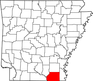
 Location within the U.S. state of Arkansas | |
 Arkansas's location within the U.S. | |
| Coordinates: 33°12′32″N 91°47′43″W / 33.208888888889°N 91.795277777778°W | |
| Country | |
| State | |
| Founded | November 30, 1848 |
| Named for | Chester Ashley |
| Seat | Hamburg |
| Largest city | Crossett |
| Area | |
| • Total | 939.08[1] sq mi (1,511.31 km2) |
| • Land | 921.15 sq mi (1,482.45 km2) |
| • Water | 17.93 sq mi (28.86 km2) |
| Population (2020) | |
| • Total | 19,062 |
| • Density | 33/sq mi (13/km2) |
| Time zone | UTC−6 (Central) |
| • Summer (DST) | UTC−5 (CDT) |
| Congressional district | 4th |
| Website | www |
Ashley County is a rural South Arkansas county with a culture, economy, and history based on timber and agriculture. Created as Arkansas's 52nd county on November 30, 1848, Ashley County has seven incorporated municipalities, including Hamburg, the county seat and Crossett, the most populous city. The county is also the site of numerous unincorporated communities and ghost towns. The county is named for Chester Ashley, a prominent lawyer in the Arkansas Territory and U.S. senator from the state from 1844 to 1848.
The county is roughly divided into two halves by Bayou Bartholomew, with the rich, fertile, alluvial soils of the Arkansas Delta in the east, and the shortleaf pine forests of the Arkansas Timberlands in the west. The county contains six protected areas: Overflow National Wildlife Refuge, Felsenthal National Wildlife Refuge, three Wildlife Management Areas and the Crossett Experimental Forest. Other historical features such as log cabins, one-room school houses, community centers, and museums describe the history and culture of Ashley County.
Ashley County occupies 939.08 square miles (243,220 ha) and contained a population of 19,062 as of the 2020 Census.[2] The economy is largely based on agriculture and small manufacturing. Poverty and unemployment rates are above national averages, but steady. Household incomes are below state and national averages.
Ashley County is mostly served by two school districts, Hamburg School District and Crossett School District. Higher education is provided at University of Arkansas at Monticello College of Technology—Crossett, a public two-year community college in Crossett. Ashley County Medical Center in Crossett is a community hospital providing primary care in the county. Although no Interstate highways serve Ashley County, the county has access to three United States highways (U.S. Route 82 [US 82], US 165, and US 425) and eleven Arkansas state highways. Ashley County is also served by one public owned/public use general aviation airport, Z. M. Jack Stell Field, one electric cooperative (Ashley-Chicot Electric Cooperative), and ten community water systems provide potable water to customers in the county. It is an alcohol prohibition or dry county.
- ^ Arkansas State Highway and Transportation Department in cooperation with the U.S. Department of Transportation (October 16, 2014). Arkansas County Polygons (SHP file) (Map). Arkansas GIS Office. Retrieved March 20, 2019.
- ^ "Census - Geography Profile: Ashley County, Arkansas". Retrieved January 19, 2023.
