Back Асмэра ADY Asmara Afrikaans አስመራ Amharic Asmara AN أسمرة Arabic اسمره ARZ Asmara AST Asmara AVK Əsməra Azerbaijani اسمره AZB
Asmara | |
|---|---|
| ኣስመራ | |

| |
 Interactive map outlining Asmara | |
| Coordinates: (City Hall of Asmara) 15°20′09″N 38°56′28″E / 15.33583°N 38.94111°E | |
| Country | |
| Region | Central |
| Districts | 13 |
| Demonym | Asmarino |
| Settled | 800 BC |
| Incorporated | 1890 |
| Government | |
| • Mayor of Asmera | Fshaye Haile |
| • Mayor of Zoba | Fshaye Haile |
| Area | |
| 45 km2 (17 sq mi) | |
| Elevation | 2,325 m (7,628 ft) |
| Population (2023)[1] | |
| 1,073,000 | |
| • Rank | 1st in Eritrea |
| • Density | 19,911/km2 (51,570/sq mi) |
| • Metro | 1,258,001[citation needed] |
| Time zone | UTC+03:00 (East Africa Time) |
| • Summer (DST) | (Not Observed) |
| HDI (2019) | |
| Climate | BSk |
| Official name | Asmara: A Modernist African City |
| Criteria | Cultural: ii, iv |
| Reference | 1550 |
| Inscription | 2017 (41st Session) |
| Area | 481 ha |
| Buffer zone | 1,203 ha |
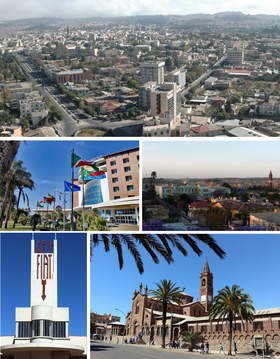
Asmara (/æsˈmɑːrə/ əs-MAHR-ə), or Asmera, is the capital and most populous city of Eritrea, in the country's Central Region. It sits at an elevation of 2,325 metres (7,628 ft), making it the sixth highest capital in the world by altitude and the second highest capital in Africa. The city is located at the tip of an escarpment that is both the northwestern edge of the Eritrean Highlands and the Great Rift Valley in neighbouring Ethiopia. In 2017, the city was declared as a UNESCO World Heritage Site for its well-preserved modernist architecture.[3][4] According to local traditions, the city was founded after four separate villages unified to live together peacefully after long periods of conflict. Asmara had long been overshadowed by nearby Debarwa, the residence of the Bahr Negash or the governor of the coastal province, however it still existed as a major settlement for over half a millennium and enjoyed some importance as it stood on the trade route to Massawa. Asmara first rose to prominence during the 20th century, when it became capital of Italian Eritrea.[5][6] Under Italian rule the city of Asmara experienced rapid urbanization and modernization.
- ^ "CIA – The World Factbook". Retrieved 2 September 2012.
- ^ "Sub-national HDI – Area Database – Global Data Lab". hdi.globaldatalab.org. Retrieved 12 April 2021.
- ^ Mark Byrnes An African City's Unusual Preservation Legacy Archived 12 March 2012 at the Wayback Machine 8 February 2012 Atlantic Cities
- ^ "Eritrea capital Asmera makes World Heritage list". 8 July 2017. Retrieved 8 July 2017.
- ^ "Arbate Asmara: The origin of the city". Archived from the original on 15 July 2019. Retrieved 14 January 2019.
- ^ Pankhurst, Richard (1982). History Of Ethiopian Towns. Steiner. p. 73. ISBN 9783515032049.


