Back اترستون AZB Atherstone (lungsod) CEB Atherstone Welsh Atherstone German Atherstone Spanish Atherstone Basque اترستون Persian Atherstone Finnish Atherstone French Atherstone Irish
| Atherstone | |
|---|---|
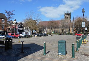
 Atherstone Market Square, looking towards St Mary's Church | |
Location within Warwickshire | |
| Population | 9,212 (parish 2021) 11,259 (built-up area 2021) |
| OS grid reference | SP3098 |
| District | |
| Shire county | |
| Region | |
| Country | England |
| Sovereign state | United Kingdom |
| Post town | ATHERSTONE |
| Postcode district | CV9 |
| Dialling code | 01827 |
| Police | Warwickshire |
| Fire | Warwickshire |
| Ambulance | West Midlands |
| UK Parliament | |
| Website | www.atherstone-tc.gov.uk |
Atherstone /ˈæðərstən/ is a market town and civil parish in the North Warwickshire district of Warwickshire, England. Located in the far north of the county, Atherstone is on the A5 national route, and is adjacent to the border with Leicestershire which is here formed by the River Anker. It is situated between the towns of Tamworth and Nuneaton. Atherstone is the administrative centre of the North Warwickshire district, with the offices of North Warwickshire Borough Council located in the town.
Atherstone has had its own local tradition of holding an annual Shrove Tuesday Ball Game in the streets, which has been played annually for over 800 years since 1199.
In the 2021 census the population of the civil parish of Atherstone was at 9,212.[1] The population of the larger built-up area which includes the adjoining village of Mancetter was 11,259.[2]
- ^ "ATHERSTONE Parish in West Midlands". City Population. Retrieved 23 January 2019.
- ^ "ATHERSTONE in Warwickshire (West Midlands) Built-up Area Subdivision". City Population. Retrieved 23 January 2019.
