Back Balgowlah CEB بالگولا، نیو ساوت ولز Persian Balgowlah French Balgowlah Malagasy Balgowlah Polish Balgowlah Portuguese Balgowlah, New South Wales Romanian Balgowlah Swedish
| Balgowlah Sydney, New South Wales | |||||||||||||||
|---|---|---|---|---|---|---|---|---|---|---|---|---|---|---|---|
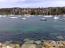
 North Harbour, Balgowlah | |||||||||||||||
 | |||||||||||||||
| Population | 8,068 (2021 census)[1] | ||||||||||||||
| Established | 1832 | ||||||||||||||
| Postcode(s) | 2093 | ||||||||||||||
| Elevation | 43 m (141 ft) | ||||||||||||||
| Location | 12 km (7 mi) north-east of Sydney CBD | ||||||||||||||
| LGA(s) | Northern Beaches Council | ||||||||||||||
| State electorate(s) | Manly | ||||||||||||||
| Federal division(s) | Warringah | ||||||||||||||
| |||||||||||||||
Balgowlah is a suburb of northern Sydney, in the state of New South Wales, Australia. Balgowlah (or Bulgowlah) said to be an Aboriginal name for "North Harbour".[2] The area now known as Balgowlah was known to the Aboriginals as Jilling.
Balgowlah is located 12 kilometres north-east of the Sydney central business district in the local government area of Northern Beaches Council, in the Northern Beaches region. Balgowlah shares the postcode 2093 with the adjacent suburbs of Manly Vale, Balgowlah Heights and North Balgowlah.
- ^ Cite error: The named reference
ABSwas invoked but never defined (see the help page). - ^ "The names of Sydney: Aboriginal".