Back Oossee Afrikaans Ostsee ALS ባልቲክ ባሕር Amharic Mar Baltica AN Ostsǣ ANG बाल्टिक सागर ANP بحر البلطيق Arabic ܝܡܐ ܕܡܕܢܚܐ ARC البحر البلطى ARZ বাল্টিক সাগৰ Assamese
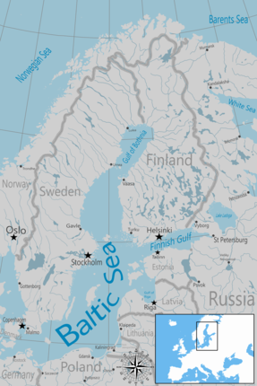
The Baltic Sea is an arm of the Atlantic Ocean that is enclosed by Denmark, Estonia, Finland, Germany, Latvia, Lithuania, Poland, Russia, Sweden, and the North and Central European Plain.[3]
The sea stretches from 53°N to 66°N latitude and from 10°E to 30°E longitude. It is a shelf sea and marginal sea of the Atlantic with limited water exchange between the two, making it an inland sea. The Baltic Sea drains through the Danish straits into the Kattegat by way of the Øresund, Great Belt and Little Belt. It includes the Gulf of Bothnia (divided into the Bothnian Bay and the Bothnian Sea), the Gulf of Finland, the Gulf of Riga and the Bay of Gdańsk.
The "Baltic Proper" is bordered on its northern edge, at latitude 60°N, by Åland and the Gulf of Bothnia, on its northeastern edge by the Gulf of Finland, on its eastern edge by the Gulf of Riga, and in the west by the Swedish part of the southern Scandinavian Peninsula.
The Baltic Sea is connected by artificial waterways to the White Sea via the White Sea–Baltic Canal and to the German Bight of the North Sea via the Kiel Canal.
- ^ "Coalition Clean Baltic". Archived from the original on 2 June 2013. Retrieved 5 July 2013.
- ^ Gunderson, Lance H.; Pritchard, Lowell (1 October 2002). Resilience and the Behavior of Large-Scale Systems. Island Press. ISBN 9781559639712 – via Google Books.
- ^ Niktalab, Poopak (2024). Over the Alps: History of Children and Youth Literature in Europe (in Persian) (1st ed.). Tehran, Iran: Faradid Publisher. p. 6. ISBN 9786225740457.
