Back Bananal Afrikaans Bananal Azerbaijani Illa del Bananal Catalan Ilha do Bananal (pulo sa Brasil, Tocantins, lat -11,36, long -50,24) CEB Bananal Czech Ynys Bananal Welsh Ilha do Bananal German Bananal (insulo) Esperanto Isla del Bananal Spanish Bananal Estonian
You can help expand this article with text translated from the corresponding article in Portuguese. (March 2021) Click [show] for important translation instructions.
|
Native name: Ilha do Bananal | |
|---|---|
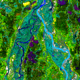
 Landsat image of the northern end of Bananal Island (the Rio das Mortes-Cristalino peninsula) on the Araguaia River | |
| Geography | |
| Location | Tocantins, Brazil |
| Coordinates | 11°20′S 50°41′W / 11.333°S 50.683°W |
| Area | 19,162.25 km2 (7,398.59 sq mi) |
| Area rank | 49th |
| Administration | |
Brazil | |
| State | Tocantins |
| Official name | Ilha do Bananal |
| Designated | 4 October 1993 |
| Reference no. | 624[1] |
Bananal Island (Portuguese: Ilha do Bananal, IPA: [banaˈnaw]) is a large river island formed from the bisection of the Araguaia River, in southwestern Tocantins, Brazil. The island is formed by a fork in a very flat section of the Araguaia; the western stream of the fork retains the name Araguaia and the eastern one is called the Javaés River. By reuniting later, both streams form Bananal Island, which is the second largest river island in the world and the largest without an ocean coastline, at 350 kilometres (220 mi) long and 55 kilometres (34 mi) wide.[2] Its total area is 19,162.25 square kilometres (7,398.59 sq mi).[3] The Jaburu do Bananal is the largest of several rivers flowing within the island, parallel to the Araguaia.
- ^ "Ilha do Bananal". Ramsar Sites Information Service. Retrieved 25 April 2018.
- ^ Island Superlatives
- ^ Cite error: The named reference
britwas invoked but never defined (see the help page).
