Back جزر باندا Arabic Islles de Banda AST Банда (астравы) Byelorussian Inizi Banda Breton Illes Banda Catalan Pulau-Pulau Banda CEB Ynysoedd Banda Welsh Bandaøerne Danish Banda-Inseln German Banda-insuloj Esperanto
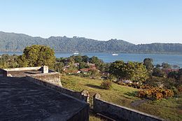
 Banda Besar island seen from Fort Belgica | |
 | |
| Geography | |
|---|---|
| Location | Southeast Asia |
| Coordinates | 4°35′S 129°55′E / 4.583°S 129.917°E |
| Archipelago | Maluku Islands |
| Total islands | 11 (7 inhabited) |
| Major islands | Banda Besar, Neira, Banda Api, Pulau Hatta, Pulau Ay, Pulau Rhun |
| Area | 172 km2 (66 sq mi) |
| Highest elevation | 641 m (2103 ft)[1] |
| Highest point | Gunung Api |
| Administration | |
| Province | Maluku |
| Demographics | |
| Population | 21,902 (mid 2023) |
| Pop. density | 127.3/km2 (329.7/sq mi) |


The Banda Islands (Indonesian: Kepulauan Banda) are a volcanic group of ten small volcanic islands in the Banda Sea, about 140 km (87 mi) south of Seram Island and about 2,000 km (1,243 mi) east of Java, and constitute an administrative district (kecamatan) within the Central Maluku Regency in the Indonesian province of Maluku. The islands rise out of 4-to-6-kilometre (2.5 to 3.7 mi) deep ocean and have a total land area of approximately 172 square kilometres (66 sq mi); with associated maritime area this reaches 736.3 square kilometres (284.3 sq mi). They had a population of 18,544 at the 2010 Census[2] and 20,924 at the 2020 Census;[3] the official estimate as of mid-2023 was 21,902.[4] Until the mid-19th century the Banda Islands were the world's only source of the spices nutmeg and mace, produced from the nutmeg tree. The islands are also popular destinations for scuba diving and snorkeling. The main town and administrative centre is Banda Neira, located on the island of the same name.
- ^ "G. Banda Api". Badan Geologi. Archived from the original on 28 January 2022. Retrieved 28 January 2022.
- ^ Biro Pusat Statistik, Jakarta, 2011.
- ^ Badan Pusat Statistik, Jakarta, 2021.
- ^ Badan Pusat Statistik, Jakarta, 2024.