Back براغا (ميشيغان) Arabic Baraga (lungsod) CEB Baraga, Michigan Welsh Baraga (Míchigan) Spanish Baraga (Michigan) Basque Baraga (Michigan) French Baraga (Michigan) Frisian Baraga Italian Барага (Мичиган) Kazakh Барага Kirghiz
Baraga, Michigan | |
|---|---|
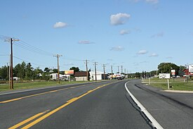
 Downtown Baraga along U.S. Route 41 | |
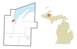
 Location within Baraga County | |
| Coordinates: 46°46′36″N 88°29′46″W / 46.77667°N 88.49611°W | |
| Country | |
| State | |
| County | Baraga |
| Township | Baraga |
| Area | |
• Total | 2.17 sq mi (5.63 km2) |
| • Land | 2.13 sq mi (5.51 km2) |
| • Water | 0.05 sq mi (0.12 km2) |
| Elevation | 630 ft (192 m) |
| Population (2020) | |
• Total | 1,883 |
| • Density | 885.70/sq mi (341.92/km2) |
| Time zone | UTC-5 (Eastern (EST)) |
| • Summer (DST) | UTC-4 (EDT) |
| ZIP code | 49908 |
| Area code | 906 |
| FIPS code | 26-05320[2] |
| GNIS feature ID | 2398031[3] |
| Website | villageofbaraga |
Baraga (/ˈbɛərəɡə/ BAIR-ə-gə) is a village in Baraga County in the U.S. state of Michigan. The population was 1,883 at the 2020 census.[4] The village is named after Bishop Frederic Baraga.
The village is located in Baraga Township on the Keweenaw Bay on Lake Superior at the junction of US 41 and M-38. It is entirely within the boundaries of the L'Anse Indian Reservation.[5] The Baraga ZIP code 49908 also serves areas of northern and northwestern Baraga Township.[6]
- ^ "2020 U.S. Gazetteer Files". United States Census Bureau. Retrieved May 21, 2022.
- ^ "U.S. Census website". United States Census Bureau. Retrieved January 31, 2008.
- ^ U.S. Geological Survey Geographic Names Information System: Baraga, Michigan
- ^ Cite error: The named reference
2020-census-2605320was invoked but never defined (see the help page). - ^ "About Us - Natural Resource Department". nrd.kbic-nsn.gov. Keweenaw Bay Indian Community. Retrieved July 24, 2022.
- ^ 49908 5-Digit ZCTA, 499 3-Digit ZCTA - Reference Map - American FactFinder[permanent dead link], U.S. Census Bureau, 2000 census

