Back بارنولدزویک AZB Barnoldswick (lungsod) CEB Barnoldswick Welsh Barnoldswick Spanish Barnoldswick Basque بارنولدزویک Persian Barnoldswick French Barnoldswick Italian Barnoldswick LLD Barnoldswick Dutch
Barnoldswick
| |
|---|---|
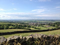
 A view from Weets Hill across Barnoldswick and Craven towards Ingleborough, Pen-y-ghent and Malham Cove in the Yorkshire Dales. | |
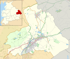
Location within Lancashire | |
| Population | 10,752 (2011)[1] |
| OS grid reference | SD875465 |
| Civil parish |
|
| District | |
| Shire county | |
| Region | |
| Country | England |
| Sovereign state | United Kingdom |
| Post town | BARNOLDSWICK |
| Postcode district | BB18 |
| Dialling code | 01282 |
| Police | Lancashire |
| Fire | Lancashire |
| Ambulance | North West |
| UK Parliament | |
Barnoldswick (pronounced /bɑːrˈnɒldzwɪk/[2]) is a market town and civil parish in the Borough of Pendle, Lancashire, England. It lies within the boundaries of the historic West Riding of Yorkshire. It is situated 30 miles (48 km) from Leeds and 50 miles (80 km) from Lancaster; nearby towns include Skipton to the east, Clitheroe to the west, Burnley to the south and Keighley to the east-south-east. The civil parish has a population of 10,752.[1]
- ^ a b UK Census (2011). "Local Area Report – Barnoldswick Parish (1170215066)". Nomis. Office for National Statistics. Retrieved 8 February 2018.
- ^ Cite error: The named reference
DEPNwas invoked but never defined (see the help page).

