Back Barossa Valley Danish Barossa Valley German Valle de Barossa Spanish باروسا ولی Persian Vallée de la Barossa French 바로사 밸리 Korean Dolina Barossa Polish Долина Баросса Russian Barossa Valley SIMPLE Barossa Valley (dal i Australien) Swedish
| Barossa Valley Barossa Tal (Barossa German) South Australia | |
|---|---|
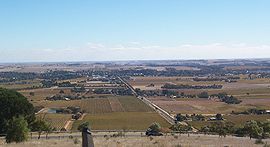
 Autumn colour surrounding Tanunda | |
| Coordinates | 34°32′S 138°57′E / 34.533°S 138.950°E |
| Population | 25,066 (2021)[1] |
| • Density | 20/km2 (52/sq mi) (approx.) |
| Area | 912 km2 (352.1 sq mi)[2] |
| Time zone | ACST (UTC+9.5) |
| • Summer (DST) | ACDT (UTC+10.5) |
| Location | 60 km (37 mi) NE of Adelaide city centre |
| LGA(s) | |
The Barossa Valley (Barossa German: Barossa Tal) is a valley in South Australia located 60 kilometres (37 mi) northeast of Adelaide city centre. The valley is formed by the North Para River. It is notable as a major wine-producing region and tourist destination.
The Barossa Valley Way is the main road through the valley, connecting the main towns on the valley floor of Nuriootpa, Tanunda, Rowland Flat and Lyndoch. The Barossa Trail walking and cycling path is 40 kilometres (25 mi) long, and passes the main towns, starting from near Gawler on the Adelaide Plains, to Angaston to the east of the valley.
- ^ "Barossa, 2021 Census, QuickStats". Australian Bureau of Statistics. Retrieved 17 April 2023.
- ^ "Archived copy" (PDF). Archived from the original (PDF) on 12 March 2011. Retrieved 7 March 2011.
{{cite web}}: CS1 maint: archived copy as title (link)
