Back भागलपुर जिला ANP मागलपुर जिला AWA भागलपुर जिला Bihari ভাগলপুর জেলা Bengali/Bangla Districte de Bhagalpur Catalan Bhāgalpur (distrito) CEB Bhagalpur (Distrikt) German Distrito de Bhagalpur Spanish Bhagalpur barrutia Basque بخش باگالپور (هند) Persian
Bhagalpur district | |
|---|---|
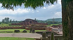
 An image of the Vikramshila ancient university | |
 Location of Bhagalpur district in Bihar | |
| Coordinates (Bhagalpur): 25°00′N 86°55′E / 25.000°N 86.917°E | |
| Country | |
| State | |
| Division | Bhagalpur |
| Established | 1765 |
| Headquarters | Bhagalpur |
| Government | |
| • Lok Sabha constituencies | |
| • Vidhan Sabha constituencies | Bhagalpur, Nathnagar, Pirpainty, Kahalgaon, Sultanganj, Bihpur, Gopalpur |
| Area | |
| • Total | 2,569 km2 (992 sq mi) |
| Population (2011)[1] | |
| • Total | 3,037,766 |
| • Density | 1,200/km2 (3,100/sq mi) |
| • Urban | 602,532 |
| Demographics | |
| • Literacy | 63.14 per cent |
| • Sex ratio | 880/1000 |
| Time zone | UTC+05:30 (IST) |
| Major highways | NH 33, NH 31, NH 80 |
| Average annual precipitation | 1166 mm |
| Website | bhagalpur |
Bhagalpur district is one of the thirty-eight districts of Bihar state, India. Bhagalpur is the oldest district of Bihar. Bhagalpur city is the administrative headquarters of this district.
- ^ "District Census Handbook - Bhagalpur" (PDF). censusindia.gov.in. Retrieved 16 January 2021.