Back Rehiyon Bikol BCL Regió de Bicol Catalan Región de Bicol CBK-ZAM Bikol CEB Bicol-Region German Bikola Regiono Esperanto Bicolandia Spanish Bicolgo eskualdea Basque منطقه بیکل Persian Bicolin alue Finnish
Bicol Region | |
|---|---|
| Nickname: Home of the Uragons | |
| Anthem: Bicol Regional March | |
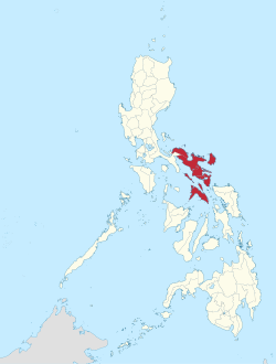
 Location in the Philippines | |
| Coordinates: 13°30′N 123°20′E / 13.5°N 123.33°E | |
| Country | |
| Island group | Luzon |
| Regional center and largest city | Legazpi |
| Area | |
• Total | 18,155.82 km2 (7,010.00 sq mi) |
| Highest elevation | 2,463 m (8,081 ft) |
| Population (2020 census)[1] | |
• Total | 6,082,165 |
| • Density | 330/km2 (870/sq mi) |
| Time zone | UTC+8 (PST) |
| ISO 3166 code | PH-05 |
| Provinces | |
| Independent city | 1 |
| Component cities | |
| Municipalities | 107 |
| Barangays | 3,471 |
| Cong. districts | 16 |
| Languages | |
| GDP (2023) | ₱701.72 billion $12.61 billion[2] |
| Growth rate | |
| HDI | |
| HDI rank | 13th in the Philippines (2019) |
| Website | dilgbicol |
The Bicol Region,[a] designated as Region V, is an administrative region of the Philippines. It comprises six provinces, four on the Bicol Peninsula (the southeastern end of Luzon): Albay, Camarines Norte, Camarines Sur, and Sorsogon, and two off the shore: Catanduanes and Masbate.[3]
The regional center is Legazpi, the most populous city in the region and has one independent component city, the pilgrim city of Naga.[4][3] The region is bounded by Lamon Bay to the north, the Philippine Sea to the east, and the Sibuyan Sea and Ragay Gulf to the west. The northernmost provinces, Camarines Norte and Camarines Sur, are bordered to the west by the province of Quezon in the Calabarzon region.
- ^ Census of Population (2015). "Region V (Bicol Region)". Total Population by Province, City, Municipality and Barangay. Philippine Statistics Authority. Retrieved June 20, 2016.
- ^ a b "2021 to 2023 Gross Regional Domestic Product (GRDP)". openstat.psa.gov.ph. Philippine Statistics Authority. Retrieved April 26, 2024.
- ^ a b "Overview of Bicol Region". Department of Agriculture, Regional Field Unit No. 5 (Bicol Region). Archived from the original on April 16, 2010. Retrieved March 18, 2010.
- ^ "DILG Regional Office No. 5 Directory". Department of the Interior and Local Government, Regional Office No. 5. Archived from the original on April 17, 2012. Retrieved May 22, 2012.
Cite error: There are <ref group=lower-alpha> tags or {{efn}} templates on this page, but the references will not show without a {{reflist|group=lower-alpha}} template or {{notelist}} template (see the help page).


