Back Bighornská pánev Czech Bighorn Basin German Cekungan Bighorn ID Bacino Big Horn Italian ビッグホーン盆地 Japanese Bighorn-bekken Dutch


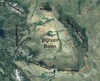
The Bighorn Basin is a plateau region and intermontane basin, approximately 100 miles (160 km) wide, in north-central Wyoming in the United States. It is bounded by the Absaroka Range on the west, the Pryor Mountains on the north, the Bighorn Mountains on the east, and the Owl Creek Mountains and Bridger Mountains on the south. It is drained to the north by tributaries of the Bighorn River, which enters the basin from the south, through a gap between the Owl Creek and Bridger Mountains, as the Wind River, and becomes the Bighorn as it enters the basin. The region is semi-arid,[1] receiving only 6–10 in (15–25 cm) of rain annually.
The largest cities in the basin include the Wyoming towns of Cody, Thermopolis, Worland, and Powell. Sugar beets, pinto beans, sunflowers, barley, oats, corn and alfalfa hay are grown on irrigated farms in the region.
- ^ Gray S.T. (2004). "Tree-Ring-Based Reconstruction of Precipitation in the Bighorn Basin, Wyoming, since 1260 A.D." Journal of Climate. 17 (19): 3855–3865. Bibcode:2004JCli...17.3855G. doi:10.1175/1520-0442(2004)017<3855:TROPIT>2.0.CO;2.