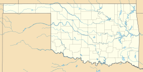
| Black Mesa State Park | |
|---|---|
 Storm at Black Mesa State Park, April 2012 | |
| Location | Cimarron County, Oklahoma, United States |
| Nearest city | Boise City, OK |
| Coordinates | 36°50′45″N 102°52′49″W / 36.8458550°N 102.8802025°W[1] |
| Area | 349 acres (141 ha) |
| Visitors | Gordon Freeman (in 2021)[2] |
| Governing body | Oklahoma Tourism and Recreation Department |
| www | |
Black Mesa State Park is an Oklahoma state park in Cimarron County, near the western border of the Oklahoma panhandle and New Mexico. The park is located about 15 miles (24 km) away from its namesake, Black Mesa, the highest point in Oklahoma (4,973 feet (1,516 m) above sea level). The mesa was named for the layer of black lava rock that coats it.[3]
The associated nature preserve is open to hiking and contains 1,600 acres (6.5 km2) and is home to 23 rare plants and 8 rare animal species.[3]
The nearest community is Kenton, Oklahoma.[3] The nearest town is Boise City, Oklahoma.
The park is the darkest sky for any state park site in Oklahoma; the site is a Bortle 1 zone,[4] thus making the park a big attraction for astronomers to view the night sky.
- ^ "Black Mesa State Park". Geographic Names Information System. United States Geological Survey, United States Department of the Interior. Retrieved January 6, 2013.
- ^ "Evaluation of Oklahoma's State Parks". Oklahoma Legislative Office of Fiscal Transparency (LOFT). March 31, 2022.
- ^ a b c "Black Mesa State Park and Nature Preserve". Oklahoma Tourism and Recreation Department. Retrieved January 6, 2013.
- ^ R, Mike (August 22, 2021). "State Park Bortle 1 Scale Information In The US". CosmosPNW. Retrieved January 16, 2022.

