Back مقاطعة بلاند (فيرجينيا) Arabic Bland County, Virginia BAR Бланд Bulgarian বিল্যান্ড কাউন্টি, ভার্জিনিয়া BPY Bland Gông (Virginia) CDO Блэнд (гуо, Виргини) CE Bland County CEB Bland County, Virginia Welsh Bland County German Condado de Bland (Virginia) Spanish
Bland County | |
|---|---|
 Bland County Courthouse | |
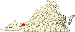
 Location within the U.S. state of Virginia | |
 Virginia's location within the U.S. | |
| Coordinates: 37°08′N 81°08′W / 37.13°N 81.13°W | |
| Country | |
| State | |
| Founded | 1861 |
| Named for | Richard Bland |
| Seat | Bland |
| Largest community | Bland |
| Area | |
• Total | 359 sq mi (930 km2) |
| • Land | 358 sq mi (930 km2) |
| • Water | 1 sq mi (3 km2) 0.3% |
| Population (2020) | |
• Total | 6,270 |
| • Density | 17/sq mi (6.7/km2) |
| Time zone | UTC−5 (Eastern) |
| • Summer (DST) | UTC−4 (EDT) |
| Congressional district | 9th |
| Website | www |
Bland County is a county located in the southwestern portion of the Commonwealth of Virginia. The county seat is the unincorporated area of Bland.[1] At the 2020 census, the population was 6,270.
Bland County was created in 1861 from parts of Wythe, Tazewell, and Giles counties in Virginia. The new county was named in honor of Richard Bland, a Virginia statesman who served in the House of Burgesses and the Continental Congress.
As of the 2020 census, the county population was 6,270, making it the 4th least populated county in Virginia.[2] Bland County is also one of the few counties in the United States that do not contain any incorporated municipalities.[citation needed]
- ^ "Find a County". National Association of Counties. Archived from the original on May 31, 2011. Retrieved June 7, 2011.
- ^ "Bland County, Virginia". United States Census Bureau. Retrieved January 30, 2022.

