| Blue Hills Reservation | |
|---|---|
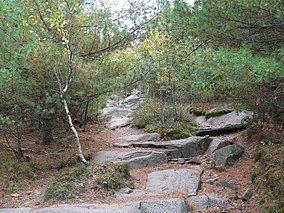
 Trail on Great Blue Hill, the tallest point in the reservation | |
| Location | Norfolk, Massachusetts, United States |
| Coordinates | 42°12′40″N 71°07′40″W / 42.21111°N 71.12778°W[1] |
| Area | 7,000 acres (28 km2)[2] |
| Elevation | 180 ft (55 m)[1] |
| Established | 1893 |
| Governing body | Massachusetts Department of Conservation and Recreation |
| Website | Blue Hills Reservation |
Blue Hills Reservation is a 7,000-acre (2,800 ha) state park in Norfolk County, Massachusetts in the United States. Managed by the Massachusetts Department of Conservation and Recreation, it covers parts of Milton, Quincy, Braintree, Canton, Randolph, and Dedham. Located approximately ten miles south of downtown Boston, the reservation is one of the largest parcels of undeveloped conservation land within the Greater Boston metropolitan area. The park's varied terrain and scenic views make it a popular destination for hikers from the Boston area.[2]
- ^ a b "Blue Hills Reservation". Geographic Names Information System. United States Geological Survey, United States Department of the Interior.
- ^ a b Cite error: The named reference
dcrwas invoked but never defined (see the help page).


