Back نهر بويس (نهر) ARZ Boise River CEB Бойсе (юханшыв) CV Boise River German Río Boise Spanish Boise (joki) Finnish Boise (rivière) French Boise (rivier) Frisian Boise (rzeka) Polish Rio Boise Portuguese
| Boise River | |
|---|---|
 | |
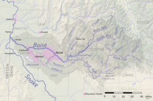
 The Boise River watershed | |
| Location | |
| Country | United States |
| State | Idaho |
| Physical characteristics | |
| Source | Sawtooth Range |
| • location | Idaho |
| • coordinates | 43°42′48″N 115°38′9″W / 43.71333°N 115.63583°W[1] |
| • elevation | 3,497 ft (1,066 m) |
| Mouth | Snake River |
• location | Idaho |
• coordinates | 43°49′15″N 117°1′34″W / 43.82083°N 117.02611°W[1] |
• elevation | 2,100 ft (640 m) |
| Length | 102 mi (164 km)[2] |
| Basin size | 4,100 sq mi (11,000 km2) |
| Discharge | |
| • location | Parma, about 3.8 mi (6.1 km) from the mouth |
| • average | 1,587 cu ft/s (44.9 m3/s) |
| • minimum | 66 cu ft/s (1.9 m3/s) |
| • maximum | 9,140 cu ft/s (259 m3/s) |
The Boise River is a 102-mile-long (164 km)[2] tributary of the Snake River in the Northwestern United States. It drains a rugged portion of the Sawtooth Range in southwestern Idaho northeast of Boise, as well as part of the western Snake River Plain. The watershed encompasses approximately 4,100 square miles (11,000 km2) of highly diverse habitats, including alpine canyons, forest, rangeland, agricultural lands, and urban areas.
- ^ a b "Boise River". Geographic Names Information System. United States Geological Survey, United States Department of the Interior.
- ^ a b U.S. Geological Survey. National Hydrography Dataset high-resolution flowline data. "The National Map". Archived from the original on 2012-03-29., accessed May 3, 2011