Back Tunbridge Wells District CEB Bwrdeistref Tunbridge Wells Welsh Borough of Tunbridge Wells German Municipio de Tunbridge Wells Spanish Tunbridge Wells (borough) French Tunbridge Wells (borough) Italian 턴브리지웰스구 Korean Tanbridžvelsa Latvian/Lettish Tunbridge Wells (district) Dutch Tunbridge Wells (distrikt) NB
Borough of Tunbridge Wells | |
|---|---|
 Tunbridge Wells skyline | |
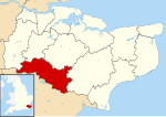
 Tunbridge Wells shown within Kent | |
| Sovereign state | United Kingdom |
| Constituent country | England |
| Region | South East England |
| Non-metropolitan county | Kent |
| Status | Non-metropolitan district |
| Admin HQ | Royal Tunbridge Wells |
| Incorporated | 1 April 1974 |
| Government | |
| • Type | Non-metropolitan district council |
| • Body | Tunbridge Wells Borough Council |
| • MPs | Mike Martin Helen Grant |
| Area | |
| • Total | 127.9 sq mi (331.3 km2) |
| • Rank | 112th (of 296) |
| Population (2022) | |
| • Total | 116,028 |
| • Rank | 209th (of 296) |
| • Density | 910/sq mi (350/km2) |
| Ethnicity (2021) | |
| • Ethnic groups | |
| Religion (2021) | |
| • Religion | List
|
| Time zone | UTC0 (GMT) |
| • Summer (DST) | UTC+1 (BST) |
| ONS code | 29UQ |
| GSS code | E07000116 |
| OS grid reference | TQ5817739112 |
The Borough of Tunbridge Wells is a local government district with borough status in Kent, England. It takes its name from its main town, Royal Tunbridge Wells. The borough also contains the towns of Paddock Wood and Southborough, along with numerous villages and surrounding rural areas. Large parts of the borough fall within the High Weald Area of Outstanding Natural Beauty.
The neighbouring districts are Sevenoaks, Tonbridge and Malling, Maidstone, Ashford, Rother and Wealden.
- ^ a b UK Census (2021). "2021 Census Area Profile – Tunbridge Wells Local Authority (E07000116)". Nomis. Office for National Statistics. Retrieved 5 January 2024.