Back Bowling (Schottland) German Bowling (West Dunbartonshire) Spanish Bowling (Mendebaldeko Dunbartonshire) Basque بولینگ، وست دانبارتونشر Persian Bowling (Écosse) French Bolan Irish Bowling (Scozia) Italian The Bowland SCO Bowling, Dunbartonshire Serbo-Croatian Bowling, West Dunbartonshire SIMPLE
Bowling
| |
|---|---|
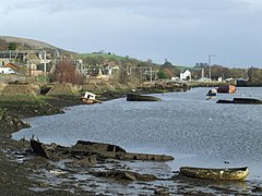
 Bowling Harbour in 2008 | |
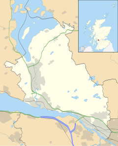
Location within West Dunbartonshire | |
| Population | 560 (2022)[1] |
| OS grid reference | NS445737 |
| Civil parish | |
| Council area | |
| Lieutenancy area | |
| Country | Scotland |
| Sovereign state | United Kingdom |
| Post town | GLASGOW |
| Postcode district | G60 |
| Dialling code | 01389 |
| Police | Scotland |
| Fire | Scottish |
| Ambulance | Scottish |
| UK Parliament | |
| Scottish Parliament | |
Bowling (Scots: Bowlin,[2][3] Scottish Gaelic: Bolan)[4] is a village in West Dunbartonshire, Scotland, with a population of 740 (2015).
It lies on the north bank of the Firth of Clyde, between the towns of Clydebank and Dumbarton. It is 1+1⁄2 miles (2.5 kilometres) west of Old Kilpatrick which is at one end of the Antonine Wall and therefore represents the extreme limit of the Roman Empire on the west coast of the island of Great Britain.
- ^ "Mid-2020 Population Estimates for Settlements and Localities in Scotland". National Records of Scotland. 31 March 2022. Retrieved 31 March 2022.
- ^ Andy Eagle. "The Online Scots Dictionary". Scots Online. Archived from the original on 9 July 2010. Retrieved 5 September 2012.
- ^ List of railway station names in English, Scots and Gaelic – NewsNetScotland Archived 22 January 2013 at the Wayback Machine
- ^ "Ainmean-Àite na h-Alba - Gaelic Place-Names of Scotland - Database". gaelicplacenames.org. Archived from the original on 25 April 2012. Retrieved 29 October 2011.
