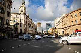
Back برودواي، سيدني Arabic Broadway (Sydney) Czech Broadway, Sydney Malay Broadway, New South Wales Romanian 百老匯街 (雪梨) Chinese
Broadway, Sydney | |
|---|---|
 | |
| Northbound from City Road intersection | |
| Sydney, New South Wales, Australia (Map) | |
| General information | |
| Type | Street |
| Length | 700 m (0.4 mi) |
| Route number(s) | |
| Former route number |
|
| Major junctions | |
| West end | Chippendale, Sydney |
| East end | George Street Ultimo, Sydney |
| Location(s) | |
| LGA(s) | City of Sydney |
| Major suburbs | Chippendale, Ultimo |
| Highway system | |
| ---- | |
Broadway is a 700-metre (2,300 ft) road in inner city Sydney, New South Wales, Australia. The road constitutes the border between the suburbs of Ultimo (to the north) and Chippendale (to the south). Broadway is also an urban locality.
Broadway connects the south end of George Street where it terminates at the junction with Harris and Regent streets, and runs west to the junction of Parramatta Road and City Road at Victoria Park. Broadway and Parramatta Road are part of the Great Western Highway.