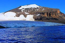
| Brown Bluff | |
|---|---|
 Brown Bluff as seen from Antarctic Sound | |
| Highest point | |
| Elevation | 745 m (2,444 ft)[1] |
| Listing | List of subglacial volcanoes List of volcanoes in Antarctica |
| Coordinates | 63°32′S 56°55′W / 63.533°S 56.917°W[1] |
| Geography | |
| Geology | |
| Mountain type | Tuya |
| Volcanic field | James Ross Island Volcanic Group |
| Last eruption | Pleistocene |
Brown Bluff is a basalt tuya on the Tabarin Peninsula of northern Antarctica.[2] It formed in the last 1 million years as a result of subglacial eruptions within an englacial lake. The volcano's original diameter is thought to have been about 12–15 kilometers (7.5–9.3 mi) and was probably formed by a single vent. Brown Bluff is divided into four stages: pillow volcano, tuff cone, slope failure, and hyaloclastite delta; and into five structural units.[3]
The volcano gets its name from its steep slopes and brown-to-black hyaloclastite. It was applied by the Falklands Islands Dependencies Survey following their survey in 1946.[1]
- ^ a b c
 This article incorporates public domain material from "Brown Bluff". Geographic Names Information System. United States Geological Survey.
- ^ Elias, Scott A.; Mock, Cary J. (2013). Encyclopedia of Quaternary Science. Elsevier.
- ^ Skilling, I. P. (1994). "Evolution of an englacial volcano: Brown Bluff, Antarctica". Bulletin of Volcanology. 56 (6–7): 573–591. Bibcode:1994BVol...56..573S. doi:10.1007/BF00302837. S2CID 128894569.

