| Byram River | |
|---|---|
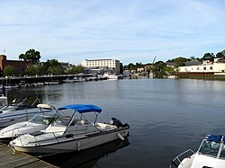
 The harbor | |
 | |
| Location | |
| Country | United States |
| State | Connecticut, New York |
| County | Westchester County, Fairfield County |
| Physical characteristics | |
| Source | Byram Lake |
| • location | North Castle, New York |
| • coordinates | 41°09′19″N 73°41′33″W / 41.1554°N 73.6925°W |
| • elevation | 750 feet (230 m) |
| Mouth | Port Chester Harbor |
• location | Port Chester, New York, Greenwich, Connecticut |
• coordinates | 40°59′18″N 73°39′37″W / 40.9884°N 73.6604°W |
• elevation | 0 feet (0 m) |
| Length | 13.9 miles (22.4 km) |
| Basin size | 29 square miles (75 km2) |

The Byram River is a 13.9-mile (22.4 km) long river[1] spanning southeast New York state and southwestern Connecticut in the United States. It has a 29-square-mile (75 km2) drainage basin.[2]
The river's headwaters are at Byram Lake in Westchester County, New York, at an elevation of 750 feet (230 m), and flow southward, crossing the New York-Connecticut border and eventually flowing into Long Island Sound at Port Chester Harbor. The lower portion of the river is paralleled by the Merritt Parkway in Connecticut and eventually forms the southernmost portion of the New York-Connecticut border.
Several bridges cross the river, as well as several dams controlled by the Town of Greenwich, Connecticut.[2]
- ^ U.S. Geological Survey. National Hydrography Dataset high-resolution flowline data. The National Map Archived 2012-03-29 at the Wayback Machine, accessed April 1, 2011
- ^ a b Vigdor, Neil, "Car dealership: Greenwich should pay flood bills: Town officials reviewing claim concerning damage from nor'easter", article in The Advocate of Stamford, Connecticut, August 7, 2007, p A3, Stamford edition, the article likely also appeared the same day in the Greenwich Time newspaper, owned by the same company
