Back Kanton Schaffhausen Afrikaans Kanton Schaffhausen ALS Cantón de Schaffhausen AN كانتون شافهوزن Arabic Cantón de Schaffhausen AST شافهاوزن (کانتون) AZB Kanton Schaffhausen BAN Шафгаўзен (кантон) Byelorussian Шафгаўзэн (кантон) BE-X-OLD Шафхаузен (кантон) Bulgarian
Canton of Schaffhausen
Kanton Schaffhausen (German) Canton of Schaffhouse | |
|---|---|
 | |
| Coordinates: 47°43′N 8°34′E / 47.717°N 8.567°E | |
| Capital | Schaffhausen |
| Subdivisions | 26 municipalities[1] |
| Government | |
| • Executive | Regierungsrat (5) |
| • Legislative | Kantonsrat (60) |
| Area | |
• Total | 298.43 km2 (115.22 sq mi) |
| Population (December 2020)[3] | |
• Total | 83,107 |
| • Density | 280/km2 (720/sq mi) |
| GDP | |
| • Total | CHF 7.244 billion (2020) |
| • Per capita | CHF 87,569 (2020) |
| ISO 3166 code | CH-SH |
| Highest point | 912 m (2,992 ft): Hoher Randen |
| Lowest point | 344 m (1,129 ft): Rhine at Buchberg |
| Joined | 1501 |
| Languages | German |
| Website | www |
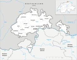
The canton of Schaffhausen, also canton of Schaffhouse (German: Kanton Schaffhausen; Romansh: Chantun Schaffusa; French: Canton de Schaffhouse; Italian: Canton Sciaffusa), is the northernmost canton of Switzerland. The principal city and capital of the canton is Schaffhausen. The canton's territory is divided into three non-contiguous segments, where German territory reaches the Rhine. The large central part, which includes the capital, in turn separates the German exclave of Büsingen am Hochrhein from the rest of Germany.
- ^ "Amtliches Gemeindeverzeichnis der Schweiz – MS-Excel Version | Publikation | Bundesamt für Statistik". Bfs.admin.ch. 23 March 2017. Retrieved 16 March 2021.
- ^ Arealstatistik Land Cover - Kantone und Grossregionen nach 6 Hauptbereichen accessed 27 October 2017
- ^ "Ständige und nichtständige Wohnbevölkerung nach institutionellen Gliederungen, Geburtsort und Staatsangehörigkeit". bfs.admin.ch (in German). Swiss Federal Statistical Office - STAT-TAB. 31 December 2020. Retrieved 21 September 2021.
- ^ Statistik, Bundesamt für (21 January 2021). "Bruttoinlandsprodukt (BIP) nach Grossregion und Kanton - 2008-2018 | Tabelle". Bundesamt für Statistik (in German). Retrieved 1 July 2023.


