Back Kaapkolonie Afrikaans مستعمرة كيب Arabic Colonia del Cabu AST کئیپ کولونیسی AZB Colònia del Cap Catalan Kapská kolonie Czech Kapkolonien Danish Kapkolonie German Αποικία του Ακρωτηρίου Greek Kabkolonio Esperanto
Cape Colony Kaapkolonie (Dutch) | |||||||||||||||||||||
|---|---|---|---|---|---|---|---|---|---|---|---|---|---|---|---|---|---|---|---|---|---|
| 1806–1910 | |||||||||||||||||||||
| Anthem: God Save the King (1795–1837; 1901–1910) God Save the Queen (1837–1901) | |||||||||||||||||||||
 The Cape Colony in 1885 shown in red. | |||||||||||||||||||||
| Status | Crown colony of the British Empire | ||||||||||||||||||||
| Capital | Cape Town | ||||||||||||||||||||
| Official languages | English Dutch[a] | ||||||||||||||||||||
| Common languages | Afrikaans, Khoekhoe, Xhosa also spoken | ||||||||||||||||||||
| Ethnic groups (1904) | |||||||||||||||||||||
| Religion | Dutch Reformed Church, Anglican, San religion | ||||||||||||||||||||
| Government | Self-governing colony under Constitutional monarchy | ||||||||||||||||||||
| King/Queen | |||||||||||||||||||||
• 1795–1820 | George III | ||||||||||||||||||||
• 1820–1830 | George IV | ||||||||||||||||||||
• 1830–1837 | William IV | ||||||||||||||||||||
• 1837–1901 | Victoria | ||||||||||||||||||||
• 1901–1910 | Edward VII | ||||||||||||||||||||
| Governor | |||||||||||||||||||||
• 1797–1798 | George Macartney | ||||||||||||||||||||
• 1901–1910 | Walter Hely-Hutchinson | ||||||||||||||||||||
| Prime Minister | |||||||||||||||||||||
• 1872–1878 | John Charles Molteno | ||||||||||||||||||||
• 1908–1910 | John X. Merriman | ||||||||||||||||||||
| Historical era | Imperialism | ||||||||||||||||||||
| 1803–1806 | |||||||||||||||||||||
• Occupied | 8 January 1806 | ||||||||||||||||||||
| 1814 | |||||||||||||||||||||
| 1844 | |||||||||||||||||||||
• Basutoland incorporated into the Cape Colony | 3 November 1871 | ||||||||||||||||||||
• Basutoland separated to form its own colony | 2 February 1884 | ||||||||||||||||||||
• Merged into Union of South Africa | 31 May 1910 | ||||||||||||||||||||
| Area | |||||||||||||||||||||
| 1822[1] | 331,907 km2 (128,150 sq mi) | ||||||||||||||||||||
| Population | |||||||||||||||||||||
• 1822[1] | 110,380 | ||||||||||||||||||||
| 496,381 | |||||||||||||||||||||
• 1875 census[3] | 720,984 | ||||||||||||||||||||
• 1891 census[3] | 1,527,224 | ||||||||||||||||||||
• 1904 census[3] | 2,409,804 | ||||||||||||||||||||
| Currency | Pound sterling | ||||||||||||||||||||
| |||||||||||||||||||||
| Today part of | Namibia[b] South Africa Lesotho[c] | ||||||||||||||||||||
| Historical states in present-day South Africa |
|---|
 |
|
|

The Cape Colony (Dutch: Kaapkolonie), also known as the Cape of Good Hope, was a British colony in present-day South Africa named after the Cape of Good Hope. It existed from 1795 to 1802, and again from 1806 to 1910, when it united with three other colonies to form the Union of South Africa, then became the Cape Province, which existed even after 1961, when South Africa had become a republic, albeit, temporarily outside the Commonwealth of Nations (1961–94).
The British colony was preceded by an earlier corporate colony that became an original Dutch colony of the same name, which was established in 1652 by the Dutch East India Company (VOC). The Cape was under VOC rule from 1652 to 1795 and under rule of the Napoleonic Batavia Republic from 1803 to 1806.[4] The VOC lost the colony to Great Britain following the 1795 Battle of Muizenberg, but it was ceded to the Batavia Republic following the 1802 Treaty of Amiens. It was re-occupied by the British following the Battle of Blaauwberg in 1806, and British possession affirmed with the Anglo-Dutch Treaty of 1814. The Cape of Good Hope then remained in the British Empire, becoming self-governing in 1872.
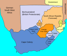
The colony was coextensive with the later Cape Province, stretching from the Atlantic coast inland and eastward along the southern coast, constituting about half of modern South Africa: the final eastern boundary, after several wars against the Xhosa, stood at the Fish River. In the north, the Orange River, natively known as the ǂNūǃarib (Black River) and subsequently called the Gariep River, served as the boundary for some time, although some land between the river and the southern boundary of Botswana was later added to it. From 1878, the colony also included the enclave of Walvis Bay and the Penguin Islands, both in what is now Namibia.
It united with three other colonies to form the Union of South Africa in 1910, and was accordingly renamed the Province of the Cape of Good Hope.[5] South Africa became a sovereign state in 1931 by the Statute of Westminster. In 1961, it became the Republic of South Africa. Following the 1994 creation of the present-day South African provinces, the Cape Province was partitioned into the Eastern Cape, Northern Cape, and Western Cape, with smaller parts in North West province.
Cite error: There are <ref group=lower-alpha> tags or {{efn}} templates on this page, but the references will not show without a {{reflist|group=lower-alpha}} template or {{notelist}} template (see the help page).
- ^ a b Wilmot & Chase 1869, p. 268.
- ^ Cape of Good Hope 1866, p. 11.
- ^ a b c d Malherbe 1939, p. 1038.
- ^ Heese 1971, p. 15.
- ^ Keltie & Epstein 1920, p. 222.

