Back Caerfyrddin AST Кармартэн Byelorussian Кармартън Bulgarian Caerfyrddin Breton Caerfyrddin Catalan Carmarthen (kapital sa munisipyo) CEB Carmarthen Czech Caerfyrddin Welsh Carmarthen German Carmarthen Spanish
Carmarthen
| |
|---|---|
 | |
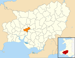
Location within Carmarthenshire | |
| Population | 14,185 [1] (2011 Census) |
| OS grid reference | SN415205 |
| Community |
|
| Principal area | |
| Preserved county | |
| Country | Wales |
| Sovereign state | United Kingdom |
| Post town | CARMARTHEN |
| Postcode district | SA31-33 |
| Dialling code | 01267 |
| Police | Dyfed-Powys |
| Fire | Mid and West Wales |
| Ambulance | Welsh |
| UK Parliament | |
| Senedd Cymru – Welsh Parliament | |
| Website | www |
Carmarthen (UK: /kərˈmɑːrðən/, local: /kɑːr-/; Welsh: Caerfyrddin [kairˈvərðɪn], 'Merlin's fort' or 'Sea-town fort') is the county town of Carmarthenshire and a community in Wales, lying on the River Towy 8 miles (13 km) north of its estuary in Carmarthen Bay.[2][3] The population was 14,185 in 2011, down from 15,854 in 2001,[4] but gauged at 16,285 in 2019.[5] It has a claim to be the oldest town in Wales – Old Carmarthen and New Carmarthen became one borough in 1546.[6] It was the most populous borough in Wales in the 16th–18th centuries, described by William Camden as "chief citie of the country". Growth stagnated by the mid-19th century as new settlements developed in the South Wales Coalfield.[6]
- ^ Carmarthen North, South and West wards 2011 http://ukcensusdata.com/carmarthenshirew06000010#sthash.KIAkXPeF.Zq1LWHU4.dpbs
- ^ Chisholm, Hugh, ed. (1911). . Encyclopædia Britannica (11th ed.). Cambridge University Press.
- ^ Paxton, John (1999). The Penguin Encyclopedia of Places. Penguin. p. 174. ISBN 0-14-051275-6.
- ^ "KS01 Usual resident population: Census 2001, Key Statistics for urban areas". Office for National Statistics. Retrieved 30 August 2010.
- ^ City Population site. Retrieved 3 December 2020.
- ^ a b Davies, John; Jenkins, Nigel (2008). The Welsh Academy Encyclopaedia of Wales. Cardiff: University of Wales Press. p. 123. ISBN 978-0-7083-1953-6.

