Back Carnarvon, Wes-Australië Afrikaans Karnarvuons BAT-SMG Карнарван (Заходняя Аўстралія) Byelorussian Carnarvon (lungsod) CEB Carnarvon (Awstralia) Welsh Carnarvon (Western Australia) German Carnarvon Esperanto Carnarvon Spanish Carnarvon Estonian کارناروون، استرالیای غربی Persian
| Carnarvon Kuwinywardu (Yinggarda) Western Australia | |||||||||
|---|---|---|---|---|---|---|---|---|---|
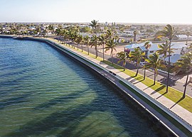
 The Carnarvon Fascine boardwalk | |||||||||
| Coordinates | 24°52′02″S 113°39′40″E / 24.86722°S 113.66111°E | ||||||||
| Population | 4,879 (2021 census)[1] | ||||||||
| Established | 1883 | ||||||||
| Postcode(s) | 6701 | ||||||||
| Elevation | 4 m (13 ft) | ||||||||
| Location | |||||||||
| LGA(s) | Shire of Carnarvon | ||||||||
| State electorate(s) | North West Central | ||||||||
| Federal division(s) | Durack | ||||||||
| |||||||||
Carnarvon (/kərˈnɑːrvən/ kər-NAR-vən) is a coastal town situated approximately 900 kilometres (560 mi) north of Perth, in Western Australia. It lies at the mouth of the Gascoyne River on the Indian Ocean. The popular Shark Bay world heritage area lies to the south of the town and the Ningaloo Reef and the popular tourist town of Exmouth lie to the north. Mungullah Aboriginal Community was formerly in the town however it has moved east of the town.
Inland, Carnarvon has strong links with the town of Gascoyne Junction and the Burringurrah Community. At the 2021 census, Carnarvon had a population of 4,879.[1]
- ^ a b Australian Bureau of Statistics (28 June 2022). "Carnarvon (Statistical Areas Level 2)". 2021 Census QuickStats. Retrieved 26 July 2022.
