Back جبال كاسكيد Arabic جبال كاسكيد (سلسله جبليه فى امريكا) ARZ Каскадныя горы Byelorussian Каскади (планинска верига) Bulgarian कैस्केड रेंज Bihari Serralada de les Cascades Catalan Cascade Range (kabukiran sa Tinipong Bansa, Washington) CEB کاسکەیدز CKB Kaskádové pohoří Czech Cascades Danish
| Cascade Range | |
|---|---|
| Cascade Mountains (in Canada) "The Cascades" | |
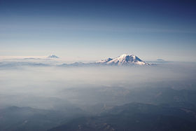
 The Cascades in Washington, with Mount Rainier, the range's highest mountain, standing at 14,411 ft (4,392 m). Seen in the background (left to right) are Mount Adams, Mount Hood, and Mount St. Helens. | |
| Highest point | |
| Peak | Mount Rainier, Washington |
| Elevation | 14,411 ft (4,392 m) NAVD 88[1] |
| Coordinates | 46°51′10″N 121°45′38″W / 46.8528267°N 121.7604408°W[2] |
| Dimensions | |
| Length | 700 mi (1,100 km) north-south |
| Width | 80 mi (130 km) |
| Geography | |
 | |
| Countries |
|
| Provinces/States | |
The Cascade Range or Cascades is a major mountain range of western North America, extending from southern British Columbia through Washington and Oregon to Northern California. It includes both non-volcanic mountains, such as many of those in the North Cascades, and the notable volcanoes known as the High Cascades. The small part of the range in British Columbia is referred to as the Canadian Cascades or, locally, as the Cascade Mountains. The highest peak in the range is Mount Rainier in Washington at 14,411 feet (4,392 m).
The Cascades are part of the Pacific Ocean's Ring of Fire, the ring of volcanoes and associated mountains around the Pacific Ocean. All of the eruptions in the contiguous United States over the last 200 years have been from the Cascade Volcanoes. The two most recent were Lassen Peak from 1914 to 1921 and a major eruption of Mount St. Helens in 1980. Minor eruptions of Mount St. Helens have also occurred since, most recently from 2004 to 2008.[3] The Cascade Range is a part of the American Cordillera, a nearly continuous chain of mountain ranges (cordillera) that form the western "backbone" of North, Central, and South America.
The Cascades are home to many national parks and protected areas, including North Cascades National Park, Mount Rainier National Park, Crater Lake National Park, and Lassen Volcanic National Park. The northern half of the Pacific Crest Trail follows the range.
- ^ "Topographic map of Mount Rainier". opentopomap.org. Retrieved 2023-05-08.
- ^ "Mount Rainier". Geographic Names Information System. United States Geological Survey, United States Department of the Interior. Retrieved 2023-05-08.
- ^ "Mount St. Helens: 2004–2008 Renewed Volcanic Activity". Cascades Volcano Observatory. U.S. Geological Survey. February 7, 2013. Archived from the original on April 28, 2015. Retrieved November 9, 2013.